Rancho Tehama, California facts for kids
Quick facts for kids
Rancho Tehama
Rancho Tehama Reserve
|
|
|---|---|

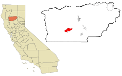
Location in Tehama County and the state of California
|
|
| Country | |
| State | |
| County | Tehama |
| Area | |
| • Total | 11.717 sq mi (30.345 km2) |
| • Land | 11.639 sq mi (30.144 km2) |
| • Water | 0.078 sq mi (0.201 km2) 0.66% |
| Population
(2010)
|
|
| • Total | 1,485 |
| • Density | 126.74/sq mi (48.937/km2) |
| Time zone | UTC-8 (Pacific (PST)) |
| • Summer (DST) | UTC-7 (PDT) |
| ZIP codes |
96021, 96080
|
| Area code(s) | 530 |
| FIPS code | 06-59604 |
| Website | – Rancho Tehama Association |
Rancho Tehama, also known as the Rancho Tehama Reserve, is a small, spread-out community in Tehama County, California, United States. It's a rural area, meaning it's mostly countryside, not a big city. Many people who live here have large plots of land where they grow crops like olives, walnuts, and almonds.
In 2010, about 1,485 people lived in Rancho Tehama. This number was a bit higher than in 2000, when there were 1,406 residents. The United States Census Bureau counts Rancho Tehama as a special statistical area called a census-designated place (CDP). This helps them collect information about the population.
Contents
Geography of Rancho Tehama
Rancho Tehama is located in California, a state in the western United States. It's part of Tehama County.
Area and Water
According to the United States Census Bureau, the total area of Rancho Tehama is about 11.7 square miles (30.3 square kilometers). Most of this area, about 11.6 square miles (30.1 square kilometers), is land. A small part, about 0.1 square miles (0.2 square kilometers), is water. This means about 0.66% of the area is covered by water.
Local Communication
If you wanted to call someone in Rancho Tehama using a landline phone, their number would start with (530) 585. This is the local phone code for the area.
Rancho Tehama Airport
There's also a small airport nearby called Rancho Tehama Airport. It's located at coordinates 40 degrees, 0 minutes, 57 seconds North and 122 degrees, 23 minutes, 23 seconds West. This airport is listed in the National Geographic Names Database.
People of Rancho Tehama
This section shares details about the people who live in Rancho Tehama, based on information collected during the 2010 United States Census.
Population Growth
In 2010, the population of Rancho Tehama was 1,485 people. This was an increase from the 1,406 people counted in the year 2000. This means more people moved to or were born in the area during those ten years.
Population Density
The population density tells us how many people live in each square mile. In Rancho Tehama, there were about 126.7 people living per square mile (or 48.9 people per square kilometer). This shows it's not a very crowded place.
Diversity of Residents
The census also looks at the different backgrounds of the people living in an area. In 2010, the people in Rancho Tehama included:
- 1,181 people (79.5%) who identified as White.
- 21 people (1.4%) who identified as African American.
- 52 people (3.5%) who identified as Native American.
- 21 people (1.4%) who identified as Asian.
- 5 people (0.3%) who identified as Pacific Islander.
- 102 people (6.9%) from other races.
- 103 people (6.9%) who identified with two or more races.
- Also, 214 people (14.4%) identified as Hispanic or Latino, which can be of any race.
Living Arrangements
All the people counted in Rancho Tehama lived in regular homes, not in group living places like dorms or institutions.
There were 587 households in total. A household is a group of people living together in one home.
- 143 households (24.4%) had children under 18 living there.
- 289 households (49.2%) were married couples.
- 63 households (10.7%) had a female head of the house with no husband present.
- 42 households (7.2%) had a male head of the house with no wife present.
- 148 households (25.2%) were just one person living alone.
- 57 of these single-person households (9.7% of all households) had someone 65 or older living alone.
The average number of people in each household was 2.53. There were 394 families, with an average family size of 2.96 people.
Age Groups
The ages of the people in Rancho Tehama were spread out:
- 295 people (19.9%) were under 18 years old.
- 110 people (7.4%) were between 18 and 24 years old.
- 253 people (17.0%) were between 25 and 44 years old.
- 509 people (34.3%) were between 45 and 64 years old.
- 318 people (21.4%) were 65 years old or older.
The median age, which is the middle age of all the people, was 48.5 years. For every 100 females, there were about 100.4 males. For every 100 females aged 18 and over, there were about 102.7 males.
Housing
There were 776 housing units in Rancho Tehama. A housing unit is a house, apartment, or other place where people live. The average density was 66.2 housing units per square mile.
Out of the homes where people lived:
- 476 (81.1%) were owned by the people living in them.
- 111 (18.9%) were rented.
Most people, 1,150 (77.4% of the population), lived in homes they owned. The remaining 335 people (22.6%) lived in rented homes.
See also
 In Spanish: Rancho Tehama Reserve para niños


