Rastatt (district) facts for kids
Quick facts for kids
Rastatt
|
||
|---|---|---|
|
||
| Country | ||
| State | Baden-Württemberg | |
| Adm. region | Karlsruhe | |
| Region | Mittlerer Oberrhein | |
| Capital | Rastatt | |
| Area | ||
| • Total | 738.77 km2 (285.24 sq mi) | |
| Population
(12.31.2008)
|
||
| • Total | 227,111 | |
| • Density | 307.4177/km2 (796.208/sq mi) | |
| Time zone | UTC+1 (CET) | |
| • Summer (DST) | UTC+2 (CEST) | |
| Vehicle registration | RA | |
| Website | http://www.landkreis-rastatt.de | |
Rastatt is a special area in the west of Baden-Württemberg, Germany. It is called a Landkreis, which means a rural district. Think of it like a county in some other countries.
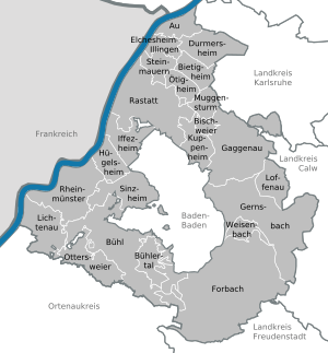
This district shares its borders with several other districts. These include Karlsruhe, Calw, Freudenstadt, and the Ortenaukreis. To the west, Rastatt borders France. Specifically, it touches the French area called Bas-Rhin. The city of Baden-Baden is completely surrounded by the Rastatt district. The main town and capital of the Rastatt district is Rastatt.
Contents
Towns and Communities in Rastatt
The Rastatt district is home to many different towns and smaller communities. These are the places where people live, work, and go to school. Each one has its own unique character.
Main Towns
- Bühl
- Gaggenau
- Gernsbach
- Kuppenheim
- Lichtenau
- Rastatt (This is the capital town of the district)
Other Communities
- Au am Rhein
- Bietigheim (Baden)
- Bischweier
- Bühlertal
- Durmersheim
- Elchesheim-Illingen
- Forbach
- Hügelsheim
- Iffezheim
- Loffenau
- Muggensturm
- Ötigheim
- Ottersweier
- Rheinmünster
- Sinzheim
- Steinmauern
- Weisenbach
Administrative Areas
To help manage the district, some smaller communities work together in groups. These are called administrative districts. They help with local services and organization.
- Bischweier-Kuppenheim
- Bühl
- Durmersheim
- Gernsbach
- Rastatt
- Rheinmünster-Lichtenau
- Sinzheim
See also
 In Spanish: Distrito de Rastatt para niños
 | William L. Dawson |
 | W. E. B. Du Bois |
 | Harry Belafonte |


