Freudenstadt (district) facts for kids
Quick facts for kids
Freudenstadt
|
||
|---|---|---|
|
||
| Country | ||
| State | Baden-Württemberg | |
| Adm. region | Karlsruhe | |
| Region | Nordschwarzwald | |
| Capital | Freudenstadt | |
| Area | ||
| • Total | 870.68 km2 (336.17 sq mi) | |
| Population | ||
| • Total | 122,292 | |
| • Density | 140.4557/km2 (363.779/sq mi) | |
| Time zone | UTC+1 (CET) | |
| • Summer (DST) | UTC+2 (CEST) | |
| Vehicle registration | FDS | |
| Website | http://www.landkreis-freudenstadt.de | |
The Freudenstadt district (also known as Landkreis Freudenstadt in German) is a special area in the middle of Baden-Württemberg, a state in Germany. Think of a district as a local government area, a bit like a county. It's where many towns and villages come together.
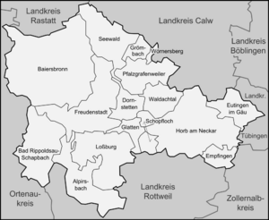
This district is surrounded by other districts like Rastatt, Calw, Tübingen, Zollernalbkreis, Rottweil, and the Ortenaukreis. The main town and capital of the Freudenstadt district is Freudenstadt.
The district is located right in the heart of the Black Forest mountains, which are famous for their beautiful scenery and dark, dense forests. The Neckar river also flows through the southeastern part of the district, adding to its natural beauty.
Towns and Communities
The Freudenstadt district is made up of several towns and smaller communities, which are like villages. These places work together to manage local services and life for everyone living there.
Main Towns
Here are the main towns in the Freudenstadt district:
- Alpirsbach
- Dornstetten
- Freudenstadt
- Horb am Neckar
Smaller Communities
These are the smaller communities or municipalities in the district:
- Bad Rippoldsau-Schapbach
- Baiersbronn
- Empfingen
- Eutingen im Gäu
- Glatten
- Grömbach
- Loßburg
- Pfalzgrafenweiler
- Schopfloch
- Seewald
- Waldachtal
- Wörnersberg
Administrative Areas
To help manage everything, these towns and communities are grouped into smaller administrative areas. These groups help with things like schools, roads, and other local needs. The main administrative areas are:
- Dornstetten
- Freudenstadt
- Horb
- Loßburg
- Pfalzgrafenweiler
See also
 In Spanish: Distrito de Freudenstadt para niños
 | Misty Copeland |
 | Raven Wilkinson |
 | Debra Austin |
 | Aesha Ash |


