
Ratibořské Hory facts for kids
Quick facts for kids
Ratibořské Hory
|
|
|---|---|
|
Municipality
|
|

Church of Saint Adalbert
|
|

Ratibořské Hory
Location in Czech Republic
|
|
| Country | |
| Region | South Bohemian |
| District | Tábor |
| Founded | 1527 |
| Area | |
| • Total | 21.14 km2 (8.16 sq mi) |
| Elevation | 418 m (1,371 ft) |
| Population
(2024-01-01)
|
|
| • Total | 811 |
| • Density | 38.36/km2 (99.36/sq mi) |
| Time zone | UTC+1 (CET) |
| • Summer (DST) | UTC+2 (CEST) |
| Postal codes |
391 42, 391 43
|
Ratibořské Hory is a small town and village in the Tábor District of the South Bohemian Region in the Czech Republic. It's home to about 800 people. The name in German is Bergstädtel, which means "mountain town."
Contents
Parts of Ratibořské Hory
Ratibořské Hory is made up of several smaller villages. These include Dub, Malenín, Podolí, Ratibořice, and Vřesce. Each of these villages is an official part of the main municipality.
Exploring the Geography of Ratibořské Hory
Ratibořské Hory is located about 9 kilometers (5.6 miles) northeast of Tábor. It is also about 57 kilometers (35 miles) northeast of České Budějovice.
Natural Landscapes and Hills
The area around Ratibořské Hory is special because it sits where three different natural regions meet.
- The northern and central parts, including Ratibořské Hory village, are in the Vlašim Uplands.
- The southwestern part, with the village of Vřesce, is in the Tábor Uplands.
- The eastern part is in the Křemešník Highlands. This area has the highest point in Ratibořské Hory, a hill called Homole. It stands tall at 667 meters (2,188 feet) above sea level.
Water Features: Fishponds
The land here is also known for its many small fishponds. These ponds add to the beautiful scenery of the region.
A Look Back at Ratibořské Hory's History
Ratibořské Hory was first established in 1527. It grew quite a lot during the 1500s.
The Rise of Mining
The town became important because of its mining activities. People mainly dug for silver ores. Many miners came from the Ore Mountain Mining Region to work here.
Changes in Ownership
- For a long time, Ratibořské Hory was owned by the king.
- In 1586, Emperor Rudolf II gave the town to the Rosenberg family.
- After the last Rosenberg family member passed away in 1611, the town became royal property again.
Later Mining Boom
Silver mining became popular again after 1737. This was when the Schwarzenberg family took over the town. By the end of the 1700s, the population grew to more than 2,000 people. This was the highest number of people living there.
Population Changes Over Time
The number of people living in Ratibořské Hory has changed over many years.
- In 1869, there were over 2,100 people.
- By 1950, the population had dropped to about 1,000.
- Today, in 2024, about 811 people live in Ratibořské Hory.
Getting Around: Transport
There are no major train lines or big roads that go through Ratibořské Hory. People mostly use smaller local roads to travel.
What to See in Ratibořské Hory
The area has some interesting historical buildings, especially churches.
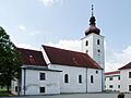
Church of Saint Adalbert
The main important building in Ratibořské Hory is the Church of Saint Adalbert.
- It was first built in the late 1300s.
- It was rebuilt into its current beautiful Baroque style between 1720 and 1722.
Church of Saint Bartholomew

Another important church is the Church of Saint Bartholomew. It is located in the village of Ratibořice.
- It was first mentioned in records in 1369.
- In the late 1700s, it was also rebuilt in the Baroque style.
- After a fire in 1849, it was rebuilt again in a Neoclassical style.
Images for kids
-
Church of Saint Adalbert
See also
 In Spanish: Ratibořské Hory para niños
