Ray's Ferry facts for kids
Ray's Ferry was a special crossing point in Louisiana. It was located on Bayou Boeuf in Avoyelles Parish. Here, a main road connecting Opelousas and Marksville crossed the water.
A ferry service helped people and goods get across the bayou. This ferry started in 1816 and ran for many years. It stopped when a modern bridge was built. The ferry was named after Reuben Ray. He was the person who got permission to operate the ferry service.
Contents
What Was Ray's Ferry?
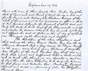
Reuben Ray received a special permit from the State of Louisiana. This permit was given on September 19, 1816. It allowed him to "keep a ferry across the Bayou Boeuf." This was on the main road from Opelousas to Avoyelles. You can still see this old permit today. It is kept in the Court Archives in Opelousas, Louisiana.
Why Was the Ferry Important?
In 1816, the road from Opelousas to Avoyelles was very important. It connected the northern and southern parts of Louisiana. Traveling by land was hard because of all the streams and bayous. Building bridges was very expensive. Bridges also made it harder for boats to travel on the water.
To help people move into the new state, ferry crossings were set up. People who owned land near the main roads often helped run these ferries. These ferry crossings became key parts of the growing road system. They made travel much easier for everyone.
The Ray Family and Their Land
Reuben Ray and his family bought land in 1812. They owned about 640 acres on the east side of Bayou Boeuf. This land was about three miles from the town of Cheneyville.
Famous Neighbor: Jim Bowie
A famous person named Jim Bowie lived nearby. He was a neighbor to the Ray family between 1814 and 1816. When he was young, Jim Bowie made money by cutting timber. He would float the timber down the bayou to sell it in New Orleans. Years later, he became a hero in the Texas Revolution. He died fighting at the Alamo.
The Ray family mostly grew cotton and corn on their land. These crops helped support the family. Around 1846, the family had financial problems. They had to sell their land along the bayou. The family then moved to another area in Louisiana, near Glenmora.
Ray's Ferry Today
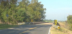
Today, parts of the old main road are now Louisiana Highway 115. A modern bridge carries LA 115 over the bayou at the historic ferry site. This spot is about two miles west of Bunkie, Louisiana.
You can find Ray's Ferry on old maps. One famous map is the "Map of Louisiana" by John Melish. This map was made using surveys from the General Land Office.
Old Boundaries
In 1821, there was a court case about land boundaries. The Supreme Court of Louisiana decided that Ray's Ferry marked the boundary. It was the line between the old "Post of Opelousas" and "Post of Rapides." These "Posts" were areas set up by the Spanish government long ago. Later, the American government changed them into different parishes, like St. Landry, Rapides, and Avoyelles.
Today, there are no signs or special markers at the site. So, you won't find any information about the historic crossing there.
 | Bayard Rustin |
 | Jeannette Carter |
 | Jeremiah A. Brown |


