Recovery Glacier facts for kids
Quick facts for kids Recovery Glacier |
|
|---|---|

Ice stream of Recovery Glacier
|
|
| Location | Coats Land |
| Coordinates | 81°10′S 28°00′W / 81.167°S 28.000°W |
| Length | 60 nmi (111 km; 69 mi) |
| Width | 40 nmi (74 km; 46 mi) |
| Thickness | unknown |
| Terminus | East Antarctic Ice Sheet |
| Status | unknown |
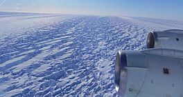
The Recovery Glacier (81°10′S 28°00′W / 81.167°S 28.000°W) is a huge river of ice found in Antarctica. It flows west along the southern side of the Shackleton Range. This glacier is very long, stretching for at least 100 km (62.137119223733 mi)*, and is about 64 km (39.767756303189 mi)* wide at its end.
It was first spotted from an airplane and then explored on the ground in 1957 by a group called the Commonwealth Trans-Antarctic Expedition. The glacier got its name, "Recovery," because the expedition's vehicles kept breaking through hidden cracks in the ice, called crevasses. The team had to work hard to "recover" their vehicles many times during their journey across Antarctica.
Contents
What is the Recovery Ice Stream?
The Recovery Ice Stream is like a giant conveyor belt of ice that feeds into the Recovery Glacier. It helps drain a large part of the East Antarctic Ice Sheet, which is the biggest ice sheet on Earth. This ice stream is incredibly long, nearly 800 km (500 mi)!
How Does the Ice Stream Move?
The Recovery Ice Stream carries ice and water towards the Filchner Ice Shelf, which floats on top of the Weddell Sea. Deep beneath this ice stream, there are four hidden subglacial lakes. These lakes can make the ice flow faster or slower. The speed of the ice can change a lot, from just 2 meters (about 6.5 feet) per year to as much as 50 meters (about 164 feet) per year!
Each year, the Recovery Ice Stream releases about 35 billion tons of water and ice into the ocean. To give you an idea, the entire East Antarctic Ice Sheet releases about 57 billion tons of ice and water every year.
How Scientists Study the Glacier
Scientists use special tools to study the Recovery Glacier. For example, in 2009, researchers from the German Aerospace Centre, Dana Floricioiu and Irena Hajnsek, shared information about the glacier. They used radar data from a satellite called Terrasar-X. When they combined this data with information from another satellite, Radarsat-1, they could see how the glacier had changed over 11 years. This helps them understand how glaciers are moving and changing over time.
Other Ice Streams Nearby
Another ice stream called the Blackwall Ice Stream also joins the Recovery Glacier. It flows between two areas known as the Argentina Range and the Whichaway Nunataks.
 | Toni Morrison |
 | Barack Obama |
 | Martin Luther King Jr. |
 | Ralph Bunche |


