Red Mountain Expressway Cut facts for kids
Quick facts for kids Red Mountain Expressway Cut |
|
|---|---|

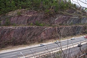
Looking east across the Red Mountain Expressway Cut.
|
|
| Lua error in Module:Location_map at line 420: attempt to index field 'wikibase' (a nil value). | |
| Location | Birmingham, Alabama |
| Area | 8 acres (3.2 ha) |
| Designated: | 1987 |
The Red Mountain Expressway Cut is a special part of Red Mountain in Birmingham, Alabama. It's also called the Red Mountain Geological Cut. In the 1960s, a large section of the mountain was blasted away. This created a path for the Red Mountain Expressway.
This important highway helps connect downtown Birmingham with nearby towns. These towns include Homewood, Mountain Brook, and Vestavia Hills. The expressway also carries major roads like U.S. Route 31 and U.S. Route 280. Building this road helped these southern towns grow a lot.
What the Cut Shows Us
The Red Mountain Expressway Cut is like a giant open book of Earth's history. When the mountain was cut, it showed layers of rock that are millions of years old. You can see about 150 million years of geological time in just 650 feet of exposed rock!
One of the most important layers is a red ore seam. This special rock helped Birmingham become a big city. It was used to make iron and steel.
Scientists have even found new types of ancient creatures here. A new kind of trilobite was discovered in these rocks. Trilobites were small sea animals that lived long, long ago. This new species was named Acaste birminghamensis, after the city of Birmingham. It was first described in 1972.
Because of its amazing geological features, the cut was named a National Natural Landmark in 1987. This means it's a very important natural place in the United States.
Why a Cut Instead of a Tunnel?
Before the Red Mountain Expressway Cut was built, engineers thought about digging a tunnel. This "Red Mountain Tunnel project" would have also connected Birmingham to its southern neighbors.
They looked at a few different paths for the tunnel. However, the tunnel idea was eventually dropped. It would have been very expensive to build. It also would have taken a very long time to finish. So, instead of a tunnel, they decided to make the Red Mountain Expressway Cut.
 | Tommie Smith |
 | Simone Manuel |
 | Shani Davis |
 | Simone Biles |
 | Alice Coachman |

