Red River Floodway facts for kids
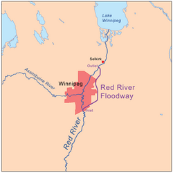
The Red River Floodway is a special waterway in Manitoba, Canada. It was built to control floods and protect the city of Winnipeg. This channel is about 47 kilometers (29 miles) long. During floods, it helps move some of the Red River's water around Winnipeg. The water flows to the east of the city and then goes back into the Red River near Lockport.
The Floodway can carry a lot of water. It was first built to handle 2,550 cubic meters (90,000 cubic feet) of water per second. After being expanded, it can now manage up to 4,000 cubic meters (140,000 cubic feet) per second.
People used to call it "Duff's Ditch." This was a nickname given by those who didn't want it built. It was named after Duff Roblin, who was the Premier (leader) of Manitoba. His government started the project after a very bad flood in 1950.
The Floodway was finished on time and didn't cost more than planned. It has been very successful. Since it was completed in 1968, it has saved over $40 billion (Canadian dollars) in flood damage. In 2000, it was named a National Historic Site of Canada. This shows how important and well-built it is.
The Floodway goes through parts of Winnipeg and other nearby areas. These include Ritchot, Springfield, East St. Paul, and St. Clements.
Contents
Building the Floodway
Construction of the Red River Floodway began on November 27, 1962. It took about five and a half years to build, finishing in March 1968. Building this channel was a huge job. Workers had to dig out 76.5 million cubic meters (2.75 billion cubic feet) of earth. This is more dirt than what was moved to build the Suez Canal!
At the time, it was the second largest earth-moving project in the world. Only the Panama Canal involved moving more earth. The total cost to build the Floodway was $63 million Canadian dollars back then. Today, that would be about $505 million.
How the Floodway Works
The Floodway system is more than just the channel itself. It also includes dikes (earth walls) along the river through Winnipeg. There's also a special dike called the "Brunkild Z-dike" to the west of the city. This dike was built in 1997 during a very big flood. That flood was so large that water almost went over the city's dikes. Thanks to the Floodway, Winnipeg had very little damage.
After the 1997 flood, experts looked at the Floodway again. They found that it could pass 2,550 cubic meters (90,000 cubic feet) per second. But this would mean some bridges would be underwater. So, they decided to make the Floodway even bigger.
The Brunkild dike is important because it controls how much water can be sent around the city. In 2003, plans were made to expand the Floodway. The goal was to increase its capacity from 1,700 cubic meters (60,000 cubic feet) per second to 4,000 cubic meters (140,000 cubic feet) per second.
Engineers decided to make the Floodway wider instead of deeper. This was because of the ground conditions. There are many underground water sources (aquifers) in the area. These aquifers provide drinking water for people in the countryside. Making the Floodway deeper could have polluted these water sources. It could also cause water to burst out from underground. Widening the channel was the safest choice.
Floodway Flow Records
Here are some of the highest water flows recorded in the Red River Floodway since it was built:
| Year | Peak Flow (cubic feet per second) | Peak Flow (cubic meters per second) |
|---|---|---|
| 1997 | 66,400 | 1,880 |
| 2009 | 43,100 | 1,220 |
| 1979 | 42,000 | 1,190 |
| 1996 | 38,800 | 1,100 |
| 1974 | 36,700 | 1,040 |
| 2011 | 36,700 | 1,040 |
Floodway Expansion Project
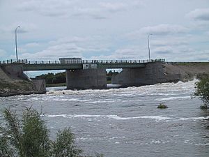
After the big flood in 1997, governments decided to greatly improve flood protection for Winnipeg. Work on the "Red River Floodway Expansion" started in late 2005. This project involved many changes. They modified railway and road crossings. They also upgraded the structures that control water flow. Existing dikes, including the Brunkild dike, were made taller. The entire Floodway channel was made wider.
The expansion was completed in late 2010. It cost more than $665 million Canadian dollars. Now, the Floodway can handle 4,000 cubic meters (140,000 cubic feet) of water per second. This is enough to protect against a very rare flood, one that might happen only once every 700 years.
This expanded Floodway now protects over 140,000 homes and more than 8,000 businesses. It is expected to prevent over $12 billion (Canadian dollars) in damage to the economy if a very large flood occurs.
Other Flood Control Efforts
In 2009, the city of Fargo in the United States started thinking about building its own floodway. This would be similar to the Red River Floodway in Canada. Fargo had serious floods in 1997 and 2009. These events made them consider building a diversion channel to protect their city.
 | Isaac Myers |
 | D. Hamilton Jackson |
 | A. Philip Randolph |


