Redkey, Indiana facts for kids
Quick facts for kids
Redkey, Indiana
|
|
|---|---|

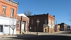
High Street, downtown
|
|

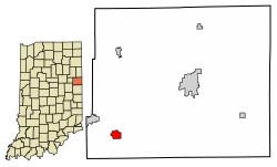
Location of Redkey in Jay County, Indiana.
|
|
| Country | United States |
| State | Indiana |
| County | Jay |
| Township | Richland |
| Area | |
| • Total | 0.87 sq mi (2.26 km2) |
| • Land | 0.87 sq mi (2.26 km2) |
| • Water | 0.00 sq mi (0.00 km2) |
| Elevation | 968 ft (295 m) |
| Population
(2020)
|
|
| • Total | 1,100 |
| • Density | 1,262.92/sq mi (487.40/km2) |
| Time zone | UTC-5 (Eastern (EST)) |
| • Summer (DST) | UTC-4 (EDT) |
| ZIP code |
47373
|
| Area code(s) | 765 |
| FIPS code | 18-63450 |
| GNIS feature ID | 2396871 |
Redkey is a small town located in Jay County, Indiana, in the United States. It is part of Richland Township. In 2010, about 1,353 people lived there. By 2020, the population was 1,100 people.
History of Redkey
Redkey got its name from James Redkey. He helped plan new parts of the town when a railroad was built through it in 1867. Before that, the area was called the Wade Settlement. This name came from Josiah Wade's family, who settled there in 1836.
Josiah's son, William Harrison Wade, planned a small village there in 1854. He named it Mt. Vernon. James Redkey added his own planned area in 1856. However, when they wanted to open a government post office, the name Mt. Vernon was already in use by another town in Indiana. So, they chose the name Redkey instead. Redkey officially became a town in 1883.
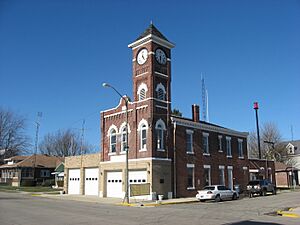
The Redkey Historic District is a special area in town. It was added to the National Register of Historic Places in 1992. This means it has important buildings and history that are protected.
Geography of Redkey
Redkey is a small town in terms of size. According to information from 2010, the total area of Redkey is about 0.95 square miles (2.46 square kilometers). Almost all of this area, about 0.94 square miles (2.43 square kilometers), is land. Only a very small part, about 0.01 square miles (0.03 square kilometers), is water.
People of Redkey
| Historical population | |||
|---|---|---|---|
| Census | Pop. | %± | |
| 1880 | 386 | — | |
| 1890 | 922 | 138.9% | |
| 1900 | 2,206 | 139.3% | |
| 1910 | 1,714 | −22.3% | |
| 1920 | 1,386 | −19.1% | |
| 1930 | 1,370 | −1.2% | |
| 1940 | 1,538 | 12.3% | |
| 1950 | 1,639 | 6.6% | |
| 1960 | 1,746 | 6.5% | |
| 1970 | 1,667 | −4.5% | |
| 1980 | 1,537 | −7.8% | |
| 1990 | 1,383 | −10.0% | |
| 2000 | 1,427 | 3.2% | |
| 2010 | 1,353 | −5.2% | |
| 2020 | 1,100 | −18.7% | |
| U.S. Decennial Census | |||
Population in 2010
In 2010, there were 1,353 people living in Redkey. These people lived in 551 homes, and 365 of those were families. The town had about 1,439 people per square mile (555 people per square kilometer). There were 630 housing units, which are places where people can live.
Most of the people in Redkey were White (98.2%). A small number were African American (0.2%), Asian (0.2%), or from other races (0.5%). About 0.9% of the people were of two or more races. People of Hispanic or Latino background made up 1.4% of the population.
Out of the 551 homes, 35.8% had children under 18 living there. About 44.5% of homes had married couples living together. In 15.6% of homes, a woman was the head of the house without a husband present. In 6.2% of homes, a man was the head of the house without a wife present. About 33.8% of homes were not families.
Also, 27.9% of all homes had just one person living there. About 13.2% of homes had someone living alone who was 65 years old or older. On average, there were 2.46 people in each home and 2.96 people in each family.
The average age of people in Redkey was 37.1 years old. About 27.3% of residents were under 18. About 8.5% were between 18 and 24 years old. People aged 25 to 44 made up 25.4% of the population. Those aged 45 to 64 were 22.6%. Finally, 16.1% of the people were 65 years old or older. The town had slightly more females (51.8%) than males (48.2%).
See also
 In Spanish: Redkey (Indiana) para niños
 | Georgia Louise Harris Brown |
 | Julian Abele |
 | Norma Merrick Sklarek |
 | William Sidney Pittman |


