Redland, Texas facts for kids
Quick facts for kids
Redland, Texas
|
|
|---|---|

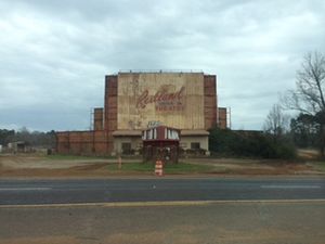
Abandoned Redland Drive In Movie Theater (demolished in 2020) in Redland, Texas
|
|
| Country | |
| State | |
| County | Angelina |
| Area | |
| • Total | 4.15 sq mi (10.74 km2) |
| • Land | 4.12 sq mi (10.68 km2) |
| • Water | 0.03 sq mi (0.07 km2) |
| Elevation | 341 ft (104 m) |
| Population
(2010)
|
|
| • Total | 1,047 |
| • Density | 252.49/sq mi (97.49/km2) |
| Time zone | UTC-6 (Central (CST)) |
| • Summer (DST) | UTC-5 (CDT) |
| ZIP code |
75901, 75904
|
| Area code(s) | 936 |
| FIPS code | 48-61124 |
| GNIS feature ID | 1382608 |
Redland is a small community in Angelina County, Texas, United States. It is known as a census-designated place (CDP). A CDP is a special area created by the U.S. Census Bureau for counting people. It helps gather information about places that are not officially cities or towns. In 2010, about 1,047 people lived in Redland. This was the first time Redland was counted as a CDP.
Contents
Exploring Redland's Location
Redland is located in the northern part of Angelina County. It is about 6 miles (10 km) north of Lufkin, which is the main city and county seat.
Highways and Travel
U.S. Route 59 is a major four-lane highway that goes through Redland. This highway connects Redland to Lufkin in the south. It also goes north about 14 miles (23 km) to Nacogdoches.
Land and Water Area
The United States Census Bureau reports that Redland covers a total area of about 4.1 square miles (10.7 square kilometers). Most of this area is land. Only a very small part, about 0.03 square miles (0.07 square kilometers), is water.
Redland's Population Facts
The population of Redland was counted during the 2010 census. At that time, 1,047 people lived in the community.
| Historical population | |||
|---|---|---|---|
| Census | Pop. | %± | |
| 2010 | 1,047 | — | |
| U.S. Decennial Census 1850–1900 1910 1920 1930 1940 1950 1960 1970 1980 1990 2000 2010 |
|||
See also
 In Spanish: Redland (Texas) para niños
 | George Robert Carruthers |
 | Patricia Bath |
 | Jan Ernst Matzeliger |
 | Alexander Miles |


