Rees River facts for kids
Quick facts for kids Rees River |
|
|---|---|
 |
|
| Country | New Zealand |
| Physical characteristics | |
| River mouth | Glenorchy 320 m |
| Length | 41 km |
| Basin features | |
| Basin size | 406 km2 |
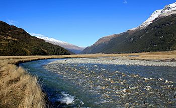
The Rees River, also known as Puahiri or Puahere in the Māori language, is a beautiful river in New Zealand. It's like a smaller stream that feeds into a much bigger river called the Clutha River / Mata-Au. The Rees River flows from the eastern side of the Southern Alps / Kā Tiritiri o te Moana, which are New Zealand's tallest mountains.
Contents
About the Rees River
The Rees River is about 41 kilometers (25 miles) long. It drains water from an area of 406 square kilometers (157 square miles). The river flows into the top end of Lake Wakatipu at a town called Glenorchy.
Where Does It Flow?
The river is surrounded by mountains. To the east are the Richardson Mountains, also known as Whakari. To the west are the Forbes Mountains. The highest parts of the river start in snowy areas over 2,000 meters (6,560 feet) high.
The upper part of the Rees River flows through a valley that was once shaped by a glacier. This glacier was called the Tyndall Glacier. Now, the Tyndall Glacier drains into the nearby Dart Valley. As the river flows further down, its valley becomes narrower. This is because of steep piles of rock and dirt that come from smaller streams joining the main river.
Fun Activities
The Rees Valley is a popular spot for outdoor adventures. The valley is covered in tussock grass and native forests. People enjoy activities like fly fishing and pack rafting here.
Hiking is also very popular. One famous trail is the Dart-Rees Track, which takes about 4 to 5 days to complete.
Staying Safe in the Valley
The Rees Valley is a wild and natural place. Because of its steep hills and the type of rock, along with heavy rain, the area can sometimes have natural events like landslides. It's important to be careful and prepared when exploring this beautiful region.
How the River Got Its Name
The Rees River and its valley are named after a large farm called a "high country station." This farm was first set up by William Gilbert Rees. He was the first person to farm sheep in the Wakatipu Basin area.
Since 1905, the Scott family has owned the Rees Valley Station. This land is kept as part of a special agreement called a Crown Pastoral Lease. This means the land is managed for farming while also protecting its natural values.
 | Kyle Baker |
 | Joseph Yoakum |
 | Laura Wheeler Waring |
 | Henry Ossawa Tanner |

