Glenorchy, New Zealand facts for kids
Quick facts for kids
Glenorchy
|
|
|---|---|
|
Town
|
|

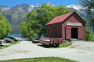
Boatshed near wharf
|
|
| Country | New Zealand |
| Region | Otago |
| Territorial authority | Queenstown Lakes District |
| Ward | Queenstown-Wakatipu Ward |
| Surveyed | 1864 |
| Electorates |
|
| Area | |
| • Total | 3.93 km2 (1.52 sq mi) |
| Population
(June 2023)
|
|
| • Total | 410 |
| • Density | 104.3/km2 (270/sq mi) |
| Time zone | UTC+12 (NZST) |
| • Summer (DST) | UTC+13 (NZDT) |
| Postcode |
9372
|
| Area code | 03 |
| Local iwi | Ngāi Tahu |
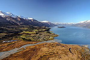
Glenorchy is a small town located at the very top of Lake Wakatipu in the South Island of New Zealand. It's part of the Otago region. The town is about 45 kilometers (28 miles) from Queenstown, which is the closest big town. You can get there by road or by boat.
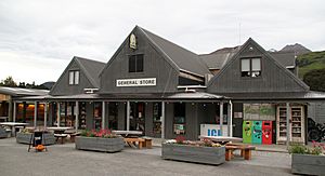
Glenorchy has a few places for visitors, like two pubs, a café, and some small shops. These places mostly serve tourists. There's also a small airstrip for planes. The area called Paradise is very close by. Two rivers, the Dart River / Te Awa Whakatipu and the Rees River, flow into Lake Wakatipu right at Glenorchy. A part of the lake's shore called Blanket Bay is just south of the town.
Contents
What's in a Name?
Glenorchy got its name from a valley in Scotland called Glen Orchy. This valley is located in a place called Argyll.
People Living in Glenorchy
Glenorchy is a small rural town. It covers an area of about 3.93 square kilometers (1.52 square miles). In 2018, about 318 people lived here. This number has been growing! In 2013, there were 261 people, and in 2006, only 192.
The people living in Glenorchy are mostly of European background (91.5%). Some people are Māori (6.6%), and smaller numbers are from the Pacific Islands or Asia. Most people (69.8%) said they didn't have a religion, while 21.7% were Christian.
Fun Things to Do
Glenorchy is a very popular place for tourists. It's close to many amazing walking tracks. The town is near the edges of both Mount Aspiring National Park and Fiordland National Park.
- The Routeburn Track is one of New Zealand's famous "Great Walks," and you can start it from Glenorchy.
- Other popular tracks nearby include the Greenstone and Caples Tracks and the Rees and Dart Tracks.
There are many exciting activities you can try in or near Glenorchy:
- Canyoning (exploring canyons)
- Fly fishing
- Jet boating
- Horse riding
- Kayaking
- Mountain biking
- Skiing and snowboarding in winter
- Skydiving
- Boating
There's also a nice, easy walk called the Glenorchy Lagoon boardwalk. It's a circular path about 3.2 kilometers (2 miles) long. It's great for both tourists and locals.
Glenorchy in Movies and TV
The beautiful scenery around Glenorchy has been used in many famous films and TV shows.
Movies Filmed Here
- The first Lord of the Rings movie, The Fellowship of the Ring (2001), used the local scenery. Places like Lothlórien and Orthanc were filmed in the nearby area of Paradise.
- Other movies filmed here include Vertical Limit (2000), The Chronicles of Narnia: Prince Caspian (2008), and X-Men Origins: Wolverine (2009).
- Race for the Yankee Zephyr (1981) and The Water Horse (2007) also filmed scenes in Glenorchy.
TV Shows Filmed Here
- The 2013 BBC TV show Top of the Lake was filmed in this area. Even though the show mentions Queenstown, Glenorchy was used as the fictional town of Laketop.
Schools in Glenorchy
Glenorchy School is a primary school for students from Year 1 to Year 8. It's a state school, meaning it's run by the government. As of March 2024, it had 30 students.
The first school in the area opened in 1884 in a place called Kinloch. Another school opened in 1888 on the road to Paradise. The current Glenorchy School started in 1911 and moved to its present location in 1939.
Weather in Glenorchy
Glenorchy has a changeable climate, typical of mountain regions. It gets a fair amount of rain throughout the year. Summers are generally mild, while winters can be cold, especially higher up in the mountains nearby.
Blanket Bay
Blanket Bay is a small bay located just south of Glenorchy. The town's airstrip is found here. The bay got its name because early farmers in the 1800s used to shear their sheep in this area. They would build simple tents from blankets near the shore to shelter themselves.
See also
 In Spanish: Glenorchy para niños
 | Toni Morrison |
 | Barack Obama |
 | Martin Luther King Jr. |
 | Ralph Bunche |


