Richland Creek (Nashville, Tennessee) facts for kids
Quick facts for kids Richland Creek |
|
|---|---|

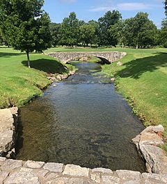
Richland Creek near Belle Meade Boulevard, Nashville
|
|
| Country | Davidson County, Tennessee, United States |
| Physical characteristics | |
| River mouth | Cumberland River 390 feet (120 m) 36°09′51″N 86°53′17″W / 36.1641°N 86.8880°W |
| Length | 28 miles (45 km) |
| Basin features | |
| Basin size | 17,712 acres (27.675 sq mi) |
Richland Creek is a stream located in the western part of Nashville, Tennessee. It flows for about 28 miles (45 km) through areas like Belle Meade and Forest Hills. Eventually, this creek joins the Cumberland River near Rock Harbor Marina. Did you know there are at least five streams named "Richland Creek" in Tennessee? This article is about the one in Nashville.
Contents
Exploring the Richland Creek Area
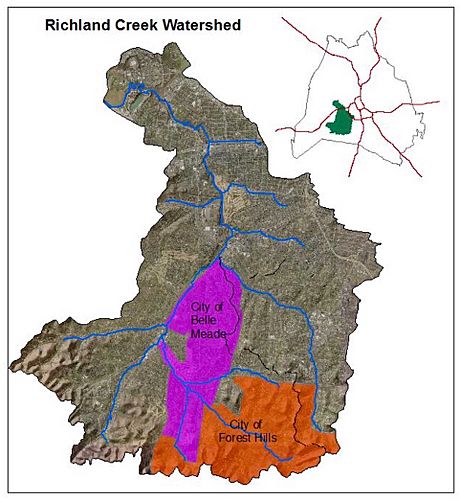
The area that drains into Richland Creek is called its watershed. This watershed covers about 17,712 acres (27.675 sq mi) within Nashville. It's located about 4 miles west of downtown Nashville.
Richland Creek gets its water from at least eight smaller streams, called tributaries. Some of these tributaries have names, and some do not. Here are a few of the named ones:
- Jocelyn Hollow Branch
- Vaughn's Gap Branch
- Chickering Branch
- Belle Meade Branch
- Sugartree Creek
- Bosley Springs Branch
- Murphy Road Branch
The creek's lowest point, where it meets the Cumberland River, is about 390 feet (120 m) above sea level. The creek starts in west Nashville where several small streams come together. One of these starts near Tyne Boulevard and flows northwest. It then joins with the Chickering Branch.
After passing under Belle Meade Boulevard, Richland Creek is joined by its Belle Meade Branch. It then flows through the golf course at Belle Meade Country Club. The creek also picks up the Vaughn's Gap Branch near Harding Academy. It continues past Belle Meade Plantation. Then, it receives the Jocelyn Hollow Branch.
Richland Creek flows past Congregation Ohabai Sholom. It picks up some small springs and goes under Harding Road. It then merges with Sugartree Creek. From there, Richland Creek winds behind St. Thomas Hospital and Aquinas College. It flows north along White Bridge Road. It also picks up the Bosley Springs Branch and the Murphy Road Branch. Finally, it reaches the Cumberland River near Briley Parkway. The part of Richland Creek closer to the Cumberland River has more industrial areas. These include a rock quarry and places that store petroleum.
History of Water Quality Challenges
Richland Creek has faced water pollution problems for a long time.
Early Pollution Concerns
Back in 1936, many dead fish were found in the Cumberland River near where Richland Creek flows in. People thought this was caused by factories dumping poisonous dyes into Richland Creek. In 1946, a report found that Nashville's sewage system was not good enough. It suggested building a sewage treatment plant. At that time, a local newspaper, The Tennessean, even called the lower part of Richland Creek "an open sewer."
Pollution in the 1970s
By 1970, people were still complaining about pollution in Richland Creek. A group of university professors studied the problem. They found that not only private industries but also Nashville's government sewer system were polluting the creek. The professors reported that raw sewage and industrial waste were flowing into the creek.
Current Environmental Status
As of 2016, there is still a warning about touching the water in Richland Creek. This is because of ongoing sewer problems. The creek is on Tennessee's "List of Impaired Waterbodies." This list includes waters that are not clean enough for certain uses.
Causes of Water Impairment
The main problem for Richland Creek is stormwater runoff. This happens when heavy rain washes pollutants from streets and other surfaces into the creek. Normally, sewage and rainwater should be kept separate. But sometimes, defects in the sewer system allow rainwater to get in. This makes the sewer system less efficient. It can cause sewage to overflow into nearby creeks.
For example, in 2011, during a construction project, sewage came to the surface. It was discovered that sewer lines had been wrongly connected to an old storm sewer. This caused sewage to go into the groundwater and then into Richland Creek. After this was fixed, the water quality improved, but other issues remained.
Steps Taken to Improve the Creek
People have been working to make Richland Creek cleaner.
Major Construction Projects
In 2009, the US Government and the State of Tennessee worked with Nashville's government. They agreed to fix sewer overflows in Richland Creek and other areas.
Construction began on the West Park Equalization Basin and a new pump station. These facilities include two large tanks. They can temporarily hold up to 31 million gallons of liquid. This helps when too much water flows into the sewer system during heavy rains. The tanks hold the extra water until the rain stops. Then, the water is sent to a treatment plant. This project helps the sewer system work better. The West Park Project was officially opened in 2018. It also includes fun places like a softball field and picnic areas. An artist even painted a mural on one of the large tanks!
Community Efforts
The Richland Creek Watershed Alliance is a group formed in 2007. They work to protect the creek's environment. They have organized volunteers to remove over 51 tons of trash from the creek. They have also planted more than 1,700 trees along the creek's banks. These efforts help keep the creek healthy for the future.
Richland Creek and Flooding
Richland Creek was involved in the severe 2010 Tennessee floods. These floods caused many deaths in Nashville. After the floods, the local government bought 61 homes that were damaged by water along Richland Creek. These homes were torn down. In their place, England Park was created. This green space helps soak up extra water from the creek during future floods. The park was named after Martha and Andy England, who sadly drowned in their home during the 2010 flood.
Images for kids
 | Tommie Smith |
 | Simone Manuel |
 | Shani Davis |
 | Simone Biles |
 | Alice Coachman |


