Rijnwoude facts for kids
Quick facts for kids
Rijnwoude
|
|||
|---|---|---|---|
|
Former municipality
|
|||

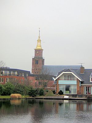
Church in Hazerswoude-Dorp
|
|||
|
|||

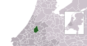
Location in South Holland
|
|||
| Country | Netherlands | ||
| Province | South Holland | ||
| Municipality | Alphen aan den Rijn | ||
| Established | 1 January 1991 | ||
| Dissolved | 1 January 2014 | ||
| Area | |||
| • Total | 57.89 km2 (22.35 sq mi) | ||
| • Land | 56.69 km2 (21.89 sq mi) | ||
| • Water | 1.20 km2 (0.46 sq mi) | ||
| Elevation | −1 m (−3.3 ft) | ||
| Population
(November 2013)
|
|||
| • Total | 18,523 | ||
| • Density | 327/km2 (850/sq mi) | ||
| Time zone | UTC+1 (CET) | ||
| • Summer (DST) | UTC+2 (CEST) | ||
| Postcode |
2390–2396, 2730–2731
|
||
| Area code | 0172, 071, 079 | ||
Rijnwoude (Dutch pronunciation: [ˈrɛiɱˌʋʌudə]) was a special type of local government area called a municipality. It was located in the western part of the Netherlands. This area is part of the South Holland province.
Rijnwoude covered about 57.89 square kilometers (22.35 square miles). A small part of this area, about 1.20 square kilometers (0.46 square miles), was water.
Contents
History of Rijnwoude
Rijnwoude was not always a single municipality. It was created in 1991. At first, it was called Rijneveld.
How Rijnwoude Was Formed
Three smaller municipalities joined together to form Rijneveld. These were Benthuizen, Hazerswoude, and Koudekerk aan den Rijn. This joining of areas is called a merger.
Renaming and Dissolution
In 1993, the name of the municipality was changed to Rijnwoude. Later, in 2014, Rijnwoude stopped being its own municipality. Its land became part of a larger municipality called Alphen aan den Rijn.
Communities of Rijnwoude
The municipality of Rijnwoude was made up of several smaller towns and villages. These communities included:
- Benthorn
- Benthuizen
- Hazerswoude-Dorp
- Groenendijk
- Hazerswoude-Rijndijk (This is where the main town hall was located.)
- Hogeveen
- Koudekerk aan den Rijn
 | George Robert Carruthers |
 | Patricia Bath |
 | Jan Ernst Matzeliger |
 | Alexander Miles |


