
Rincón barrio-pueblo facts for kids
Quick facts for kids
Rincón barrio-pueblo
Pueblo de Rincón
|
|
|---|---|
|
Municipality Seat
|
|

Rincón Town Hall
|
|

Location of Rincón barrio-pueblo within the municipality of Rincón shown in red
|
|

Rincón barrio-pueblo
Location in Caribbean
|
|
| Commonwealth | |
| Municipality | |
| Area | |
| • Total | 0.12 sq mi (0.3 km2) |
| • Land | 0.12 sq mi (0.3 km2) |
| • Water | 0 sq mi (0 km2) |
| Elevation | 26 ft (8 m) |
| Population
(2010)
|
|
| • Total | 933 |
| • Density | 7,775/sq mi (3,002/km2) |
| Source: 2010 Census | |
| Time zone | UTC−4 (AST) |
Rincón barrio-pueblo is a special kind of area in Puerto Rico. It's like the main downtown part of the Rincón municipality. Think of it as the heart of the town where important buildings are located. In 2010, about 933 people lived here.
Just like in Spain, many towns in Puerto Rico have a central area called a pueblo. This pueblo usually has a main square, government buildings like the town hall, and a Catholic church. Every year, special celebrations called Fiestas patronales (patron saint festivals) happen in this central square.
Contents
The Heart of Rincón: Plaza and Church
The main square, also known as the central plaza, is a lively spot. It's used for both official events and fun gatherings. People come here to hang out and socialize from morning until night.
Long ago, in the early 1800s, Spanish laws called the Laws of the Indies guided how towns in Puerto Rico were built. These laws said the plaza should be big enough for celebrations. They also mentioned that streets nearby should have covered walkways. These walkways would protect people from the sun and rain.
Right across from the central plaza in Rincón barrio-pueblo is a Roman Catholic church. It's called the Parroquia Santa Rosa de Lima.
| Historical population | |||
|---|---|---|---|
| Census | Pop. | %± | |
| 1900 | 1,074 | — | |
| 1910 | 1,224 | 14.0% | |
| 1920 | 1,679 | 37.2% | |
| 1930 | 1,338 | −20.3% | |
| 1940 | 1,678 | 25.4% | |
| 1950 | 1,065 | −36.5% | |
| 1980 | 1,046 | — | |
| 1990 | 1,044 | −0.2% | |
| 2000 | 1,030 | −1.3% | |
| 2010 | 933 | −9.4% | |
| U.S. Decennial Census 1899 (shown as 1900) 1910-1930 1930-1950 1980-2000 2010 |
|||
A Look at Rincón's History
In July 2020, the Federal Emergency Management Agency (FEMA) provided money to help fix up Rincón's main plaza. This shows how important the plaza is to the community.
Exploring Rincón's Neighborhoods
Barrios are like big neighborhoods or divisions within a municipality. These barrios are then divided into even smaller areas. These smaller areas are called sectores (which means sectors in English).
The names of these sectors can be different. Some are simply called sector, while others might be named urbanización, reparto, barriada, or residencial.
Here are some of the sectors you can find in Rincón barrio-pueblo:
- Calle Benjamín Gómez
- Calle Comercio
- Calle del Parque
- Calle Muñoz Rivera
- Calle Nueva
- Calle Progreso
- Calle Unión
- Cerro Los Pobres
- Cerro Miramar
- Condominio Santa Rosa Elderly
- Residencial Santa Rosa
- Sector Sol
Gallery
Places in Rincón barrio-pueblo:
-
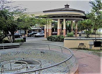
Plaza de Recreo in Rincón
-
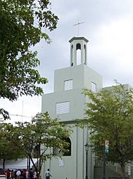
Parroquia Santa Rosa de Lima


See also
 In Spanish: Rincón (Rincón) para niños
- List of communities in Puerto Rico
- List of barrios and sectors of Rincón, Puerto Rico
