Rinconada, Jujuy facts for kids
Quick facts for kids
Rinconada
|
|
|---|---|
|
Rural municipality and village
|
|
 |
|
| Country | |
| Province | |
| Department | Rinconada Department |
| Elevation | 12,635 ft (3,851 m) |
| Population
(2001)
|
|
| • Total | 364 |
| Time zone | UTC−3 (ART) |
| Postal Code |
Y4643
|
| Area code(s) | 03885 |
| Website | www.rinconada.gov.ar |
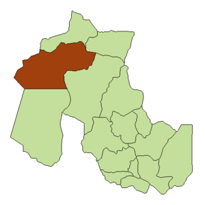
Rinconada is a small village and rural area located in the Jujuy Province of Argentina. It sits in the western part of the province and is the main town of the Rinconada Department.
What makes Rinconada special is its very high location. At 3,851 meters (about 12,635 feet) above sea level, it is the highest town in Argentina that has its own local government.
To reach Rinconada, you travel along a 62-kilometer (about 38-mile) gravel road called Provincial Route 7. This road starts just 4 kilometers (about 2.5 miles) north of Abra Pampa, which is on National Route 9. Along this route, you can find the Laguna de los Pozuelos Natural Monument. This monument is a protected area covering 150 square kilometers (about 58 square miles), known for its beautiful lake and wildlife.
What is the Climate Like in Rinconada?
Rinconada has an alpine climate. This means it's very cold, with average temperatures staying below 10 degrees Celsius (50 degrees Fahrenheit) all year round. Even in the warmest months, it doesn't get very hot.
| Climate data for Rinconada, Jujuy (1972–1996) | |||||||||||||
|---|---|---|---|---|---|---|---|---|---|---|---|---|---|
| Month | Jan | Feb | Mar | Apr | May | Jun | Jul | Aug | Sep | Oct | Nov | Dec | Year |
| Daily mean °C (°F) | 9.4 (48.9) |
9.4 (48.9) |
9.1 (48.4) |
7.0 (44.6) |
4.0 (39.2) |
2.3 (36.1) |
1.7 (35.1) |
3.6 (38.5) |
5.2 (41.4) |
7.4 (45.3) |
8.7 (47.7) |
9.2 (48.6) |
6.4 (43.5) |
| Average precipitation mm (inches) | 162 (6.4) |
123 (4.8) |
74 (2.9) |
7 (0.3) |
0 (0) |
0 (0) |
0 (0) |
0 (0) |
1 (0.0) |
5 (0.2) |
23 (0.9) |
91 (3.6) |
486 (19.1) |
| Source: Instituto Nacional de Tecnología Agropecuaria | |||||||||||||
How Many People Live in Rinconada?
When we count all the people living in the rural areas around Rinconada, it's the biggest town in its department. In 2001, there were 1,352 people living there. This was a bit less than in 1991, when the population was 1,645.
However, if we only count the people living right in the village center, the population is much smaller. Only 364 people live in the main part of Rinconada village.
See also
 In Spanish: Rinconada (Argentina) para niños
 | Emma Amos |
 | Edward Mitchell Bannister |
 | Larry D. Alexander |
 | Ernie Barnes |

