Abra Pampa facts for kids
Quick facts for kids
Abra Pampa
|
|
|---|---|
|
Municipality and town
|
|

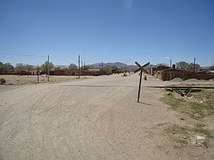
A level crossing in Abra Pampa
|
|
 |
|
| Country | |
| Province | Jujuy Province |
| Department | Cochinoca |
| Established | 30 August 1883 |
| Population | |
| • Total | 9,425 |
| Population | |
| Time zone | UTC−3 (ART) |
| Postcode |
Y4640
|
| Area code(s) | 03887 |
| Climate | BSk |
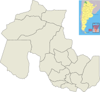
Abra Pampa is a town and municipality located in Jujuy Province, Argentina. It is the main town of the Cochinoca Department. This city is a key center for business and communication in the Puna region. It is the second most important town in the area, after La Quiaca, which is about 73 kilometers (45 miles) to the north. Abra Pampa is also connected to the provincial capital, which is 224 kilometers (139 miles) away, by a paved road called Ruta Nacional 9.
Contents
What Does "Abra Pampa" Mean?
The name "Abra Pampa" comes from two words. "Abra" is an old Spanish word that means a short opening or a ravine, which is a deep, narrow valley. In this region, it refers to a ravine. "Pampa" is a word from the Quechua language, meaning "plain" or "flat land." So, "Abra Pampa" means "ravine and plain." This name makes sense because the city is built on a flat area near several canyons, especially to the east.
A Brief History of Abra Pampa
Abra Pampa was officially founded on August 31, 1883. It was first located about 22 kilometers (14 miles) east of an older village called Cochinoca. In 1915, the town's main government offices moved to the old village of Puna, making it the capital of the department. At that time, mining was the most important business.
The new town was sometimes called "La Siberia Argentina" because of its very cold and harsh weather. However, people didn't like this name, so it went back to being known as Abra Pampa.
Early Human Life in the Puna Region
People started living in the Puna region around 13,000 years ago. For the first thousand years, they survived by hunting and gathering food. They hunted birds like rheas, vizcachas, llamas, and vicunas. They also gathered root vegetables, eggs, and the few fruits that grew in the Puna. Because of the environment, these early groups moved around a lot and didn't stay in one place for long.
About 3,000 years ago, the first farmers began to appear in the area. Towns became a common way for people to live together in one place. Abra Pampa and La Quiaca are now the biggest towns in the Jujuy Puna region. This whole area has always been home to the Quechua and Aymara people.
The Inca Influence
Around 1475, the Inca Empire took control of these populations. The Inca Trail, a famous ancient road, passed through Puna. This trail connected the northern highlands and the Inca capital, Cuzco, with what is now Chile and Mendoza. The Incas had a strong impact on the culture, trade, and religious life of the people here. Even though each group had its own leaders and language, they all used Quechua, the language of the highlands, to communicate.
During the time of Inca rule, the population grew a lot. This might have been because of better farming methods, which meant more food, longer lives, and fewer babies dying. Some people also moved to what is now Puna Argentina from other parts of the highlands. These might have been "mitimaes," which were groups of people the Incas moved to new areas to help control their empire's borders. When the Spanish arrived, the Puna region was very active in producing goods and trading.
Where is Abra Pampa Located?
Abra Pampa is located at the southern entrance of the high plateau known as the Puna Argentina. It sits at the foot of Mount Huancar. About 55 kilometers (34 miles) southwest, along provincial route 7, you can find the small but well-known village of Casabindo.
Abra Pampa connects the Puna region to the west with the forests (Yungas) and valleys to the east. Its location makes it a very important city for trade. However, even with this advantage, many people in Abra Pampa are still looking for jobs.
What is the Climate Like?
Abra Pampa has a cool semi-arid climate, which is typical for the Altiplano region. This means it has two main seasons. Throughout the year, afternoon temperatures are usually comfortable or warm. However, the temperature changes a lot between day and night because of the strong sun and thin air.
- Wet Season: From December to March, it's partly cloudy with thunderstorms. Mornings are just chilly.
- Dry Season: From April to November, it's mostly clear and sunny with very cold or freezing mornings.
July is usually the clearest month, while January is the cloudiest. February is the wettest month. Even though Abra Pampa is in the tropics, the big temperature swings between day and night make winter nights feel like those in very cold places like the northern Nordics or the Great Plains of North America.
Between 1981 and 1990, the average lowest temperature each year was about -2.4°C (27.7°F). The town experiences about 67 mornings a year where the temperature drops to -12°C (10.4°F) or even colder. The coldest months are June and July, with average low temperatures of about -11°C (12.2°F) and -12°C (10.4°F). The warmest month is December, with an average high temperature of 21.1°C (70.0°F).
| Climate data for Abra Pampa, Elevation: 3,484 metres or 11,430 feet. (1981-1990, extremes 1971-1990) | |||||||||||||
|---|---|---|---|---|---|---|---|---|---|---|---|---|---|
| Month | Jan | Feb | Mar | Apr | May | Jun | Jul | Aug | Sep | Oct | Nov | Dec | Year |
| Record high °C (°F) | 26.0 (78.8) |
27.0 (80.6) |
26.0 (78.8) |
24.0 (75.2) |
23.0 (73.4) |
20.0 (68.0) |
22.0 (71.6) |
24.0 (75.2) |
24.0 (75.2) |
26.5 (79.7) |
27.5 (81.5) |
27.0 (80.6) |
27.5 (81.5) |
| Mean daily maximum °C (°F) | 20.4 (68.7) |
19.4 (66.9) |
19.8 (67.6) |
19.1 (66.4) |
16.4 (61.5) |
14.0 (57.2) |
14.3 (57.7) |
17.0 (62.6) |
18.8 (65.8) |
20.9 (69.6) |
21.4 (70.5) |
21.1 (70.0) |
18.5 (65.3) |
| Daily mean °C (°F) | 13.0 (55.4) |
11.9 (53.4) |
12.0 (53.6) |
9.5 (49.1) |
4.8 (40.6) |
2.1 (35.8) |
1.9 (35.4) |
5.3 (41.5) |
8.2 (46.8) |
10.9 (51.6) |
12.3 (54.1) |
12.9 (55.2) |
8.7 (47.7) |
| Mean daily minimum °C (°F) | 5.9 (42.6) |
5.2 (41.4) |
4.1 (39.4) |
−1.6 (29.1) |
−8.2 (17.2) |
−11.0 (12.2) |
−12.0 (10.4) |
−9.4 (15.1) |
−6.1 (21.0) |
−1.9 (28.6) |
1.9 (35.4) |
4.5 (40.1) |
−2.4 (27.7) |
| Record low °C (°F) | −3.0 (26.6) |
−2.0 (28.4) |
−5.0 (23.0) |
−10.0 (14.0) |
−16.0 (3.2) |
−18.5 (−1.3) |
−23.0 (−9.4) |
−19.0 (−2.2) |
−18.0 (−0.4) |
−12.0 (10.4) |
−9.5 (14.9) |
−5.0 (23.0) |
−23.0 (−9.4) |
| Average precipitation mm (inches) | 94.3 (3.71) |
89.4 (3.52) |
79.7 (3.14) |
8.1 (0.32) |
0.0 (0.0) |
0.0 (0.0) |
0.0 (0.0) |
0.2 (0.01) |
0.9 (0.04) |
4.6 (0.18) |
35.0 (1.38) |
71.9 (2.83) |
387.6 (15.26) |
| Average precipitation days | 11 | 11 | 8 | 2 | 0 | 0 | 0 | 0.1 | 0.1 | 2 | 5 | 9 | 48.2 |
| Average relative humidity (%) | 66 | 65 | 62 | 50 | 41 | 40 | 36 | 38 | 35 | 43 | 53 | 60 | 49 |
| Mean monthly sunshine hours | 257.3 | 233.7 | 254.2 | 270.0 | 282.1 | 264.0 | 285.2 | 291.4 | 285.0 | 291.4 | 279.0 | 266.6 | 3,259.9 |
| Percent possible sunshine | 62 | 64 | 67 | 77 | 82 | 82 | 84 | 82 | 79 | 74 | 70 | 64 | 74 |
| Source: SMN: Estación Meteorológica Abra Pampa - Período 1981–1990 | |||||||||||||
How Many People Live in Abra Pampa?
According to a census from 2001, Abra Pampa had 7,496 people living in its urban areas. The total population for the entire municipality was 9,425 inhabitants. Some newspaper reports from August 2004 suggested a higher number of 16,000 people, but the official census data is lower.
What is the Economy of Abra Pampa Like?
Raising animals is very important for Abra Pampa's economy. People raise goats, llamas (which are American camelids related to camels), and sheep. The town was founded on August 30, 1883, and was unofficially named "capital of Puna" on August 30, 1973. It is located 3,484 meters (11,430 feet) above sea level.
The town is situated on a large flat area on the left bank of the River Miraflores. This plateau is found between the foothills of the El Aguilar and Cochinoca mountains.
What Can You See and Do in Abra Pampa?
Abra Pampa is known for a few special events and places:
- Huancar Festival: This is a local festival that takes place in the town.
- Feast of Pachamama: Celebrated in August, this feast honors Pachamama, or "Mother Earth," which is an important tradition in the Andes.
- Vicuñera de Miraflores: This is a place where semi-wild vicuñas are raised. Vicuñas are wild relatives of llamas and alpacas, known for their very fine wool. This station is run by INTA, an agricultural technology institute, and is close to the town.
See also
 In Spanish: Abra Pampa para niños
 | Leon Lynch |
 | Milton P. Webster |
 | Ferdinand Smith |

