Rioverde, San Luis Potosí facts for kids
Quick facts for kids
Rioverde
|
|
|---|---|
|
City and Municipality
|
|

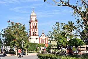
Iglesia Santa Catarina
|
|
| Country | Mexico |
| State | San Luis Potosí |
| Founded | November 3, 1552 |
| Area | |
| • Municipality | 3,064 km2 (1,183 sq mi) |
| • City | 20.45 km2 (7.90 sq mi) |
| Population
(2020 census)
|
|
| • Municipality | 97,943 |
| • Density | 31.966/km2 (82.791/sq mi) |
| • City | 58,158 |
| • City density | 2,843.9/km2 (7,365.7/sq mi) |
| Demonym(s) | Rioverdense |
| Time zone | UTC−6 (CST) |
| • Summer (DST) | UTC−5 (CDT) |
Rioverde is a vibrant city and its surrounding area, called a municipality, located in the central part of the state of San Luis Potosí, Mexico. It is one of the biggest cities in the state, known for its beautiful natural spots and pleasant weather all year round.
The city is famous for a special spring called Media Luna. Rioverde is also the hometown of famous singer Ana Bárbara and composer Amador Ramos. For students, there's a great school called the Technical Institute of Rioverde, which is a federal institute for higher education.
Contents
Discovering Rioverde: Fun Places to Visit
Rioverde has many exciting places to explore, especially if you love nature and adventure!
Media Luna Lagoon: A Natural Wonder
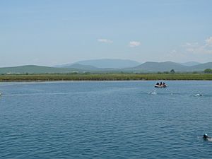
The Media Luna lagoon is a very popular place to visit, just 10 kilometers (about 6 miles) from Rioverde. Its name, "Half Moon," comes from its unique shape. This beautiful lake is perfect for swimming and camping.
The lagoon is also a favorite spot for scuba divers because it's over 50 meters (about 164 feet) deep and has an underwater cave! Scientists are also interested in the area because of the ancient remains found there.
Exploring the Caves: Cathedral and Angel
Near Rioverde, you can find amazing caverns called Las Grutas de la Catedral y del Ángel.
- Las Grutas de la Catedral (The Cathedral Caves) got their name because the rock formations inside look like a real cathedral. You can see shapes that resemble a pulpit, a choir, and even church pews!
- Gruta del Ángel (The Angel Cave) was found more recently, about 700 meters (about half a mile) from the Cathedral Caves. It's named after stalactites and stalagmites that look like an angel.
Other Nearby Adventures
- Tamasopo is another nearby attraction known for its stunning waterfalls and natural pools. It's located on Federal Highway 70, heading towards Ciudad Valles.
- Sotano de las Golondrinas (The Cave of the Swallows) is one of the largest open pit caves in the world. It's a huge, deep hole in the ground, located on the east side of the Sierra Madre Mountains from Rioverde. It's an incredible sight!
Local Traditions: Town Festivities
Just about 15 minutes from Rioverde, there are small towns like El Refugio, La Loma, San Diego, and San Martin. These towns are famous for their traditional yearly festivals, where they celebrate their local patron saints.
- San Diego holds its annual festivities in November.
- La Loma celebrates its annual festivities every year from July 4 to 12.
Geography of Rioverde
The municipality of Rioverde is located in the "Middle Zone" (Zona Media) of the state of San Luis Potosí. It's part of the Sierra Madre Oriental mountain range. The area has both high plains and mountains.
The land ranges from 100 meters (about 328 feet) to 2,600 meters (about 8,530 feet) above sea level. Rioverde shares its borders with several other municipalities and even the state of Guanajuato to the south.
Climate in Rioverde
Rioverde enjoys a pleasant climate for most of the year. The weather is generally warm, with hotter temperatures in the spring and early summer. The rainy season typically occurs during the summer months, bringing much-needed water to the region.
| Climate data for Rioverde, San Luis Potosí (1951–2010, extremes 1961–2024) | |||||||||||||
|---|---|---|---|---|---|---|---|---|---|---|---|---|---|
| Month | Jan | Feb | Mar | Apr | May | Jun | Jul | Aug | Sep | Oct | Nov | Dec | Year |
| Record high °C (°F) | 36.2 (97.2) |
39.0 (102.2) |
41.1 (106.0) |
44.0 (111.2) |
45.2 (113.4) |
43.5 (110.3) |
39.6 (103.3) |
38.8 (101.8) |
39.0 (102.2) |
38.8 (101.8) |
37.8 (100.0) |
37.0 (98.6) |
45.2 (113.4) |
| Mean daily maximum °C (°F) | 23.8 (74.8) |
26.7 (80.1) |
30.6 (87.1) |
33.4 (92.1) |
34.5 (94.1) |
33.1 (91.6) |
31.7 (89.1) |
31.7 (89.1) |
29.9 (85.8) |
28.0 (82.4) |
26.0 (78.8) |
24.2 (75.6) |
29.5 (85.1) |
| Daily mean °C (°F) | 16.2 (61.2) |
18.3 (64.9) |
21.6 (70.9) |
24.5 (76.1) |
26.3 (79.3) |
26.1 (79.0) |
25.0 (77.0) |
25.0 (77.0) |
23.8 (74.8) |
21.6 (70.9) |
19.0 (66.2) |
17.0 (62.6) |
22.0 (71.6) |
| Mean daily minimum °C (°F) | 8.5 (47.3) |
9.9 (49.8) |
12.6 (54.7) |
15.7 (60.3) |
18.2 (64.8) |
19.0 (66.2) |
18.3 (64.9) |
18.3 (64.9) |
17.8 (64.0) |
15.2 (59.4) |
12.0 (53.6) |
9.7 (49.5) |
14.6 (58.3) |
| Record low °C (°F) | −3.8 (25.2) |
−5.0 (23.0) |
−1.0 (30.2) |
1.0 (33.8) |
8.4 (47.1) |
11.0 (51.8) |
10.5 (50.9) |
10.7 (51.3) |
6.0 (42.8) |
0.0 (32.0) |
−1.9 (28.6) |
−5.0 (23.0) |
−5.0 (23.0) |
| Average precipitation mm (inches) | 12.5 (0.49) |
10.0 (0.39) |
9.8 (0.39) |
32.0 (1.26) |
36.6 (1.44) |
85.2 (3.35) |
87.2 (3.43) |
71.4 (2.81) |
96.1 (3.78) |
48.2 (1.90) |
14.4 (0.57) |
10.9 (0.43) |
514.3 (20.25) |
| Average precipitation days (≥ 0.1 mm) | 3.9 | 2.9 | 2.9 | 4.0 | 6.2 | 9.1 | 10.1 | 9.4 | 12.2 | 8.0 | 4.3 | 3.8 | 76.8 |
| Average relative humidity (%) | 69.7 | 67.1 | 61.4 | 60.8 | 66.3 | 68.5 | 71.7 | 69.5 | 74.8 | 75.7 | 73.1 | 70.6 | 69.1 |
| Mean monthly sunshine hours | 153.5 | 167.2 | 226.0 | 209.0 | 235.8 | 231.9 | 213.7 | 225.2 | 175.5 | 179.1 | 172.0 | 143.0 | 2,332 |
| Source 1: Servicio Meteorológico Nacional | |||||||||||||
| Source 2: World Meteorological Organization (relative humidity and sun 1981–2010) | |||||||||||||
See also
 In Spanish: Rioverde (San Luis Potosí) para niños
 | Frances Mary Albrier |
 | Whitney Young |
 | Muhammad Ali |


