
Risoul facts for kids
Quick facts for kids
Risoul
|
||
|---|---|---|
 |
||
|
||

Risoul
Location in France

Risoul
Location in Provence-Alpes-Côte d'Azur
|
||
| Country | France | |
| Region | Provence-Alpes-Côte d'Azur | |
| Department | Hautes-Alpes | |
| Arrondissement | Briançon | |
| Canton | Guillestre | |
| Intercommunality | Guillestre | |
| Area
1
|
30.34 km2 (11.71 sq mi) | |
| Population
(Jan. 2021)
|
Lua error in Module:Wd at line 1,575: attempt to index field 'wikibase' (a nil value). | |
| Time zone | UTC+01:00 (CET) | |
| • Summer (DST) | UTC+02:00 (CEST) | |
| INSEE/Postal code |
05119 /05600
|
|
| Elevation | 872–2,573 m (2,861–8,442 ft) (avg. 1,174 m or 3,852 ft) |
|
| 1 French Land Register data, which excludes lakes, ponds, glaciers > 1 km2 (0.386 sq mi or 247 acres) and river estuaries. | ||

Risoul is a small town, also called a commune, located in the Hautes-Alpes area of France. It's known for its beautiful mountains and is a popular spot for skiing and other outdoor activities.
People Living in Risoul
Over the years, more and more people have chosen to live in Risoul. For example, in 1962, about 287 people lived there. By 1999, the population had grown to 622 people. This shows that Risoul has become a more popular place to live.
Getting Around Risoul
You can reach Risoul by road. The main roads that go through the commune are called the D86 and D186. These roads help people get to and from the town, especially visitors coming for holidays.
Images for kids
-
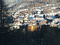
Risoul ski accommodation
-
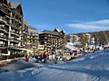
Risoul main ski station and winter park


See also
 In Spanish: Risoul para niños

All content from Kiddle encyclopedia articles (including the article images and facts) can be freely used under Attribution-ShareAlike license, unless stated otherwise. Cite this article:
Risoul Facts for Kids. Kiddle Encyclopedia.