
River Cover facts for kids
Quick facts for kids River Cover |
|
|---|---|

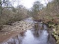
River Cover from St Simons Bridge
|
|
| Country | England |
| Physical characteristics | |
| Main source | Great Hunters Sleets nr Woodale 1,598 feet (487 m) 54°11′2″N 2°1′29″W / 54.18389°N 2.02472°W |
| River mouth | River Ure nr Middleham 322 feet (98 m) 54°16′43″N 1°46′25″W / 54.27861°N 1.77361°W |
| Length | 14 miles (22 km) |
The River Cover is a river in the beautiful Yorkshire Dales in North Yorkshire, England. It's a special place, and a group called the Yorkshire Dales Rivers Trust works hard to keep the river and its surroundings healthy. The river flows through a valley made of limestone, surrounded by very old woodlands.
Contents
Where the River Flows
The River Cover starts high up in the hills, between places called Buckden Pike and Great Whernside. It begins as many tiny streams, or "gills," that come from holes in the ground called "shake holes." When these small streams like East Stone Gill and West Stone Gill meet Hazel Bank Gill, that's where the River Cover officially begins!
The river then flows mostly towards the north-east, passing by small villages like Woodale, Braidley, and Horsehouse. It then turns a bit more north towards Gammersgill, before heading back north-east between West Scrafton and Carlton. Just after Agglethorpe, the river turns east and finally joins a bigger river called the River Ure near Middleham.
The River Cover is about 22 kilometers (around 14 miles) long. It drains water from a large area, covering more than 8,146 hectares (about 20,130 acres)!
River Animals
The River Cover is a great home for fish! You can find brown trout and grayling swimming in its waters. These fish are important parts of the river's ecosystem.
The River's Story in Rocks
The valley where the River Cover flows was shaped a long, long time ago by a glacier, which is like a giant, slow-moving river of ice. This created a U-shaped valley. The river runs over a type of rock called Great Scar limestone, and the sides of the valley are made of Yoredale rock.
The River Cover itself is a gentle river that winds and turns. It has a channel full of stones and small "beaches" along its sides, leading up to low banks covered in trees. These wooded areas also stretch up into the many small streams (gills) that flow into the main river.
Places and Crossings Along the River
Smaller Streams Joining the RiverMany smaller streams, called tributaries, flow into the River Cover, adding to its water. Here are some of them:
|
|
Towns and Villages Along the RiverThe River Cover flows past several small towns and villages. People have lived along this river for a very long time!
|
Bridges Over the RiverMany bridges help people cross the River Cover. Some are for cars, and some are just for walking!
|
Gallery
-
River Cover from St Simons Bridge
-
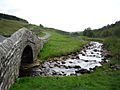
River Cover
-
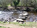
Stepping stones over the River Cover
-
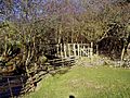
Caygill footbridge over the River Cover


