
River Kyle facts for kids
Quick facts for kids River Kyle |
|
|---|---|

Footbridge over River Kyle at Alne
54°4′41.41″N 1°14′28.56″W / 54.0781694°N 1.2412667°W |
|
| Country | England |
| Physical characteristics | |
| Main source | Confluence of Derrings Beck and Carle Beck nr Tholthorpe 12 metres (39 ft) 54°5′24″N 1°15′38″W / 54.09000°N 1.26056°W |
| River mouth | River Ouse nr Newton-on-Ouse 11 metres (36 ft) 54°2′5″N 1°13′28″W / 54.03472°N 1.22444°W |
| Length | 9.3 kilometres (5.8 mi) |
The River Kyle is a small river located in North Yorkshire, England. It is just under 6 miles (9.7 km) long, making it one of the shortest main rivers in the country.
Contents
Journey of the River Kyle
The River Kyle officially begins where two smaller streams, Carle Beck and Derrings Beck, meet. From this starting point, it flows southeast past several villages. These include Tholthorpe (near Easingwold), Flawith, Alne, and Tollerton.
When it reaches Linton-on-Ouse, the river turns south. It then joins the larger River Ouse just north of Newton-on-Ouse. From where it starts to where it ends, the River Kyle stretches for about 5.8 miles (9.3 km).
Keeping the River Clean
The River Kyle has sometimes faced challenges with pollution, mainly from farming activities. For example, in 1978, water used to put out a barn fire flowed into the river. This water carried harmful substances, which caused the river to become polluted.
Because the city of York gets its drinking water from the River Ouse, they had to temporarily stop taking water from the river. This allowed the polluted water to flow away safely. The water intakes were closed for two weeks to protect the public's water supply.
History of the River Kyle Area
Long ago, the River Kyle marked the edge of the Forest of Galtres. This was a large royal forest.
The River and Airfields
During the Second World War, an important airfield called RAF Tholthorpe was located near the start of the River Kyle. Both the Royal Air Force (RAF) and the Royal Canadian Air Force (RCAF) used this base for their planes until it closed in 1945.
The river also flows close to another airfield, RAF Linton-on-Ouse. This base first opened in 1937 and was also part of the RAF's Bomber Command during the war.
What's in a Name?
The name "Kyle" comes from an old British word, *cǖl, which means "narrow." You can still see similar words in modern languages like Welsh, Cornish, and Breton, where "cul" also means narrow. The village name Alne might even be an older name for the river itself.
Fun Activities Along the River
If you enjoy walking, there are two special walking paths from the Ordnance Survey Leisure Walking routes that cross the River Kyle near Tollerton. These paths offer a great way to explore the area around the river.
River Kyle Facts
Smaller Streams Joining the Kyle
|
Villages Along the River
|
Bridges Over the Kyle
|
Gallery
-
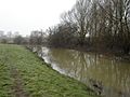
River Kyle north of Linton-on-Ouse
-
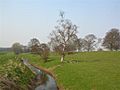
River Kyle at Tollerton
-
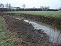
River Kyle from Carrholme Bridge


