
River Salwarpe facts for kids
The River Salwarpe is a river in Worcestershire, England. It flows for about 32.8 kilometers (20.4 miles). This river is like a smaller helper stream that flows into the larger River Severn near a place called Hawford.
Quick facts for kids River Salwarpe |
|
|---|---|

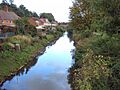
River Salwarpe in Vines Park, Droitwich
|
|

Location within Worcestershire
|
|
| Country | England |
| Counties | Worcestershire |
| Physical characteristics | |
| River mouth | River Severn 52°14′20″N 2°14′00″W / 52.2388°N 2.2334°W |
| Length | 32.8 km (20.4 mi) |
| Basin features | |
| Basin size | 196 km2 (76 sq mi) |
Contents
Where Does the River Salwarpe Flow?
The River Salwarpe starts when two smaller streams, Battlefield Brook and Spadesbourne Brook, join together in Bromsgrove. From there, the river flows through several towns and villages. These include Stoke Prior, Upton Warren, Wychbold, and Droitwich.
After passing Droitwich, the river goes through a place called Salwarpe. Finally, it meets the larger River Severn near Hawford.
River Connections and Canals
A long time ago, in the 1660s, someone tried to make the River Salwarpe wide enough for boats. This attempt was not successful. However, much later, in the 21st century, a part of the river in Droitwich was changed. It was made into a canal to connect two parts of the Droitwich Canal. This helped boats travel more easily.
The River Salwarpe also has its own smaller streams that flow into it. These are called tributaries. Some of these tributaries include the Elmbridge Brook, Hadley Brook, and Hen Brook.
How Much Water Does the Salwarpe Carry?
Scientists have been measuring how much water flows in the River Salwarpe since 1958. They do this at a special measuring spot called Harford Hill. The area of land that collects rainwater for the river, called the catchment, is about 184 square kilometers (71 square miles) at this spot.
On average, the river carries about 1.35 cubic meters (48 cubic feet) of water every second. The highest water level ever recorded at this spot was in January 1960. The water reached a height of 2.69 meters (8 feet 10 inches). At that time, the river was flowing very fast, carrying about 39 cubic meters (1,400 cubic feet) of water per second.
Rainfall and Land Around the River
The area around the Salwarpe river gets about 666 millimeters (26.2 inches) of rain each year. The highest point in this area is Beacon Hill, which is about 294 meters (965 feet) high. This hill is part of Lickey Hills Country Park. Most of the land around the river is used for farming, with fields for crops and grass for animals.
How Clean is the River Salwarpe's Water?
The Environment Agency checks the water quality of rivers in England. They give each river a rating for its overall health, called "ecological status." This rating can be high, good, moderate, poor, or bad. They look at different things to decide this. For example, they check the types and numbers of tiny creatures, plants, and fish living in the water.
They also check the "chemical status" of the water. This means they test for different chemicals to make sure they are not at harmful levels. Chemical status is rated as either good or fail.
Water Quality in 2016
Here's how the water quality of the Salwarpe and its smaller streams was rated in 2016:
| Section | Ecological Status | Chemical Status | Overall Status | Length | Catchment |
|---|---|---|---|---|---|
| Battlefield Bk - source to conf Spadesbourne Bk | Moderate | Good | Moderate | 10.4 kilometres (6.5 mi) | 19.1 square kilometres (7.4 sq mi) |
| Spadesbourne Bk - source to conf Battlefield Bk | Moderate | Good | Moderate | 5.1 kilometres (3.2 mi) | 10 square kilometres (3.9 sq mi) |
| Salwarpe - source to conf Elmbridge Bk | Poor | Good | Poor | 21.9 kilometres (13.6 mi) | 58.3 square kilometres (22.5 sq mi) |
| Elmbridge Bk - source to conf R Salwarpe | Poor | Good | Poor | 10.1 kilometres (6.3 mi) | 31.5 square kilometres (12.2 sq mi) |
| Hadley Bk - source to conf R Salwarpe | Poor | Good | Poor | 26.4 kilometres (16.4 mi) | 55.3 square kilometres (21.4 sq mi) |
| Salwarpe - conf Elmbridge Bk to conf R Severn | Poor | Good | Poor | 10.8 kilometres (6.7 mi) | 21.8 square kilometres (8.4 sq mi) |
In 2016, the water quality in the lower parts of the Salwarpe river system became worse. It changed from "moderate" to "poor." However, the two streams higher up, Battlefield Brook and Spadesbourne Brook, stayed at "moderate" quality. The chemical quality was good for the Salwarpe and all four of its monitored tributaries.
Images for kids
-
River Salwarpe in Vines Park, Droitwich
