
River Wansbeck facts for kids
Quick facts for kids River Wansbeck |
|
|---|---|

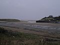
The River Wansbeck near Low Angerton
|
|

Location of mouth within Northumberland
|
|
| Country | United Kingdom |
| County | Northumberland |
| Physical characteristics | |
| Main source | West of Sweethope Loughs 295 m (968 ft) 55°08′27″N 2°08′13″W / 55.1409°N 2.137°W |
| River mouth | North Sea 55°09′43″N 1°31′46″W / 55.1619°N 1.5294°W |
| Length | 50 km (31 mi) |
| Basin features | |
| Tributaries |
|
The River Wansbeck is a river in Northumberland, England. It starts as a small stream near Sweethope Loughs. This area is known as The Wanneys. The river's name comes from this area, meaning "Wanneys Beck" (a "beck" is a small stream or river).
The Wansbeck flows through several towns and villages. These include Kirkwhelpington, Morpeth, and Mitford. In Mitford, another small river called the River Font joins the Wansbeck. Finally, the River Wansbeck reaches the North Sea at Sandy Bay, near Newbiggin-by-the-Sea.
People sometimes call the River Wansbeck the River Wanney. The phrase 'The Wilds of Wanney' is used by people from Tyneside. It describes the wild, rural areas of Northumberland where the Wansbeck begins its journey. The river also gave its name to a former local government area called Wansbeck district.
Between 1974 and 1975, a special structure called a barrage was built near the river's mouth. This project cost £250,000. A barrage is like a dam that controls the water level. It also has a navigation lock. A lock is a part of a canal or river that lets boats move between different water levels.
This barrage made the last three miles of the river into a country park. It is known as England's most northerly inland waterway that uses a lock. Even though the lock is not used very often by large boats, smaller boats like rowboats and sailboats are launched here. They enjoy the calm waters of the country park.
There are a few bridges along this navigable part of the river. Stakeford bridge is about halfway along. Sheepwash Bridge is closer to the end of the park. Since 2009, Northumberland County Council has been in charge of managing this waterway.
Bridges Over the Wansbeck
Many bridges cross the River Wansbeck as it flows through Northumberland. These bridges help people and trains get from one side of the river to the other. Some are for roads, some for railways, and many also have paths for walking.
Here are some of the bridges:
- North Seaton A189 Bridge (road, foot)
- North Seaton Railway Bridge (rail, now for freight)
- Stakeford Bridge (road, foot)
- Sheepwash Bridge (road, foot)
- Bothal Mill Bridge (road, foot)
- Pegswood Railway Viaduct (rail, on the East Coast Main Line)
- Morpeth Telford Bridge (road, foot)
- Lowford Bridge (road, foot)
- Highford Bridge (road, foot)
- A1 Bridge (road)
- Mitford Bridge (road, foot)
- Meldon Bridge (road, foot)
- Mill House Bridge (road, foot)
- Low Angerton Bridge (road, foot)
- Low Angerton Railway Bridge (disused)
- Middleton Bridge (road, foot)
- Wallington Bridge (road, foot)
- Kirkwhelpington Bridge (road, foot)
- Kirkwhelpington A696 Bridge (road)
- Sweethope Loughs Road Bridge (road, foot)
Images for kids
-
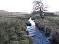
The infant River Wansbeck as a small stream
-
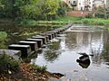
Stepping stones at Morpeth
-
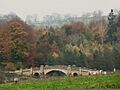
Wallington Bridge between Kirkharle and Cambo
-
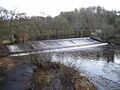
Weir at Mitford
-
The River Wansbeck meets the North Sea


