
Riverdale Road Covered Bridge facts for kids
Quick facts for kids Riverdale Road Bridge |
|
|---|---|
_Covered_Bridge_1.jpg) |
|
| Coordinates | 41°40′24″N 80°52′19″W / 41.67333°N 80.87194°W |
| Locale | Ashtabula County, Ohio, United States |
| Characteristics | |
| Design | single span, Town truss |
| Total length | 140 feet (42.7 m) |
| History | |
| Construction begin | 1874 |

Location of the bridge in Ashtabula County

Location of Ashtabula County in Ohio
|
|
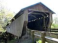
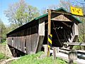
The Riverdale Road Bridge is a special covered bridge that crosses the Grand River in Morgan Township, Ashtabula County, Ohio, United States. It's one of 16 covered bridges you can still drive across in Ashtabula County! This bridge uses a unique design called a Town truss. It has been updated over the years to keep it strong and safe. For example, its floor was rebuilt in 1981, and new supports were added.
Contents
What Makes the Riverdale Road Bridge Special?
The Riverdale Road Bridge is a great example of a covered bridge. Covered bridges are like tunnels for cars, built from wood and covered with a roof and sides. This covering protects the wooden parts of the bridge from rain, snow, and sun. This helps the bridge last much longer.
How Was It Built?
The Riverdale Road Bridge uses a design called a Town truss. This type of truss was invented by Ithiel Town. It uses a crisscross pattern of wooden planks, like a lattice, to make the bridge very strong. This design helps the bridge hold a lot of weight and span long distances without needing many supports underneath.
Where Can You Find It?
This historic bridge is located in Ashtabula County, Ohio. You can find it about 1.1 miles (1.8 km) north-northwest of a town called Rock Creek. Ashtabula County is famous for its many covered bridges, and the Riverdale Road Bridge is one of its treasures.
A Look Back: The Bridge's History
The Riverdale Road Bridge has a long and interesting history, with several important updates over the years to keep it in good shape.
- 1874: The bridge was first built. Imagine how long it has been standing!
- 1945: Some of the original steel supports under the bridge were replaced. This helped make the bridge even stronger.
- 1981: The bridge got a big renovation. Workers rebuilt the floor and added special "glue-laminated wood girders." These are strong wooden beams made by gluing many layers of wood together.
- 1987: After a part of the road washed away near the east end of the bridge, a new concrete support was added. This extra support helps keep the bridge stable and safe.
Facts and Figures About the Bridge
Here are some interesting measurements for the Riverdale Road Bridge:
- Span: The distance it crosses is about 111 feet (33.8 meters).
- Total Length: The entire bridge is about 140 feet (42.7 meters) long.
- Width: It is about 12 feet 6 inches (3.8 meters) wide.
- Height: The bridge stands about 10 feet 6 inches (3.2 meters) tall.
- Overhead Clearance: If you're driving through, you have about 9 feet 6 inches (2.9 meters) of space above your vehicle.
Gallery
-
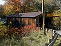
View from the southeast
-
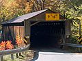
East approach
-
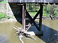
View from underneath the bridge
-
-
_Covered_Bridge_2.jpg)

.jpg)

