Rivière aux Saumons (Massawippi River tributary) facts for kids
Quick facts for kids Rivière aux Saumons |
|
|---|---|

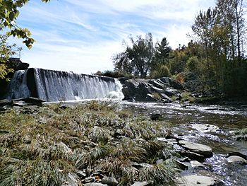
Rivière aux Saumons (Massawippi) in Martinville
|
|
| Country | Canada |
| Province | Quebec |
| Region | Estrie |
| City | Sherbrooke |
| Physical characteristics | |
| Main source | Lake Lindsay Coaticook 373 m (1,224 ft) 45°10′54″N 71°33′38″W / 45.18167°N 71.56056°W |
| River mouth | Massawippi River Sherbrooke 145 m (476 ft) 45°21′08″N 71°51′35″W / 45.35222°N 71.85972°W |
| Length | 70.6 km (43.9 mi) |
| Basin features | |
| Progression | Massawippi River, Saint-François River, Saint Lawrence River |
| Tributaries |
|
The Rivière aux Saumons is a river in Quebec, Canada. Its name means "Salmon River" in French. It flows into the Massawippi River, which then joins the Saint-François River. Finally, the Saint-François River flows into the mighty St. Lawrence River.
This river passes through several towns. These include Sainte-Edwidge-de-Clifton, Martinville, Compton, Cookshire-Eaton, and Lennoxville. It also flows through Sherbrooke, Quebec.
The main activities in the river valley are forestry and farming. These are important for the local economy.
During winter, the river usually freezes. This happens from mid-December to mid-March. However, fast-moving parts of the river (rapids) might not freeze completely. It's generally safe to be on the ice from late December to early March.
River's Journey
The Rivière aux Saumons starts its journey at a place called Lindsay Lake. This lake is about 2.3 kilometers long. It sits at an elevation of 373 meters in the Coaticook area. Two smaller streams, Madore and Moreau, feed water into Lindsay Lake.
From its source, the river flows for about 70.6 kilometers. During this journey, it drops 228 meters in height.
Upper Part of the River
The first part of the river's journey is about 39.3 kilometers long.
- It flows west for 10.2 kilometers, reaching the edge of Sainte-Edwidge-de-Clifton.
- Then, it continues west for 5.6 kilometers to a bridge on Route 251.
- Next, it turns northwest for 3.5 kilometers until it meets the Bobines stream.
- It flows northwest again for 2.6 kilometers to the Gosselin-Mills bridge.
- The river then travels northwest for 9.1 kilometers, reaching the border of Martinville.
- Finally, it flows north for 8.3 kilometers to a bridge on Route 208, near the village of Martinville.
Lower Part of the River
The second part of the river's journey is about 31.3 kilometers long.
- From the Martinville village bridge, it flows northwest for 3.8 kilometers to another bridge on Route 251.
- It continues northwest for 5.6 kilometers to a road bridge. This bridge is at the border between Compton and Cookshire-Eaton.
- The river then flows north for 3.7 kilometers to a road bridge southwest of the Johnville area in Cookshire-Eaton.
- It turns west for 9.6 kilometers, where it meets the Moe River.
- Next, it flows northwest for 5.7 kilometers to a bridge in the small community of Huntingville.
- Finally, it flows north for 2.9 kilometers until it reaches its end.
The Rivière aux Saumons empties into the Massawippi River. This meeting point is on the southeast side of the Massawippi River. It's located south of Lennoxville, about 2.9 kilometers upstream from where the Massawippi River itself ends.
River's Name
The name "Rivière aux Saumons" was officially recognized on October 6, 1983. This was done by the Commission de toponymie du Québec, which is a group that names places in Quebec.
 | Roy Wilkins |
 | John Lewis |
 | Linda Carol Brown |

