
Rivière des Roches (rivière du Berger) facts for kids
Quick facts for kids Rivière des Roches |
|
|---|---|
| Country | Canada |
| Province | Quebec |
| Region | Capitale-Nationale |
| Regional County Municipality | Quebec (city) |
| Physical characteristics | |
| Main source | Lac des Roches Quebec (city) 320 units? 46°55′07″N 71°15′42″W / 46.91861°N 71.26167°W |
| River mouth | Rivière du Berger Quebec (city) 117 m 46°53′44″N 71°17′20″W / 46.89556°N 71.28889°W |
| Length | 5.3 km (3.3 mi) |
| Basin features | |
| Tributaries |
|
The Rivière des Roches (which means 'River of Rocks' in French) is a small river in Quebec, Canada. It flows into another river called the rivière du Berger. The Rivière des Roches starts at Lac des Roches and is about 5.3 kilometers (about 3.3 miles) long. It runs through parts of Quebec City, specifically the Beauport and Charlesbourg areas.
Most of the river's valley does not have roads. However, the upper part near Lac des Roches has a few roads. The lower part of the river flows through a city area.
The river usually freezes over from early December to late March. It's generally safe to walk on the ice from late December to early March. The amount of water in the river changes with the seasons and how much it rains. The biggest flood, called the spring flood, happens in March or April.
The River's Journey
The Rivière des Roches is one of the main rivers that feed into the watershed of the rivière du Berger. It begins at Lac des Roches, which is about 320 meters (1,050 feet) above sea level. This lake is 1.4 kilometers (0.9 miles) long and is located in a wooded area north of Beauport.
From the dam at Lac des Roches, the river flows for about 5.3 kilometers (3.3 miles). It drops about 203 meters (666 feet) in height along its path. Here's how its journey goes:
- For 1.6 kilometers (1 mile), it flows south. It gets wider for a bit, forming a smaller lake called Petit lac des Roches. There's a dam built at the end of this small lake. This area is between two hills: Mont des Épinettes Noires (363 meters high) and Mont Reine-Malouin (331 meters high).
- Then, for 2.4 kilometers (1.5 miles), it continues south, dropping 105 meters (344 feet). This part of the river reaches the edge of the Orsainville neighborhood.
- Finally, for 1.3 kilometers (0.8 miles), it flows south into a residential area in the Orsainville district. Here, a special park called the Rivière-des-Roches linear park protects the river. After this park, much of the river flows through underground pipes or private land until it joins the rivière du Berger.
From where the Rivière des Roches joins the rivière du Berger, the water flows for another 15.0 kilometers (9.3 miles) through a city area. Then, it flows into the Saint-Charles River, which continues for about 8.3 kilometers (5.2 miles) through the city.
River History
Parts of the Rivière des Roches were put into underground channels during the 1970s and 1980s. This happened because new homes were being built in the area.
In 2009, there were plans to build a new neighborhood called "Domaine Rivière des Roches" further up the river. People were worried about how this would affect the environment. A meeting was held on September 15, 2009, to discuss these concerns.
Later that fall, the company building the homes started cutting down trees without permission from the city. Hundreds of trees were cut down illegally. Because of this, the project plans were changed in 2010 to better protect the river's environment. The Rivière-des-Roches linear park was created, and the city built paths and walkways there for people to enjoy.
River Name
The name "Rivière des Roches" means "River of Rocks" in French. It was given this name because the bottom of the river is very rocky.
The name "Rivière des Roches" was officially recognized on December 5, 1968, by the Commission de toponymie du Québec, which is the organization in charge of place names in Quebec.
Images for kids
-
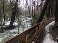
Trail along the river
-
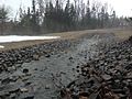
Small tributary


