Rivière du Berger facts for kids
Quick facts for kids Rivière du Berger |
|
|---|---|
| Country | Canada |
| Province | Quebec |
| Region | Capitale-Nationale |
| Regional County Municipality | Quebec (city) |
| Physical characteristics | |
| Main source | Little unidentified lake Quebec (city) 179 units? 46°55′22″N 71°18′03″W / 46.92278°N 71.30083°W |
| River mouth | Rivière du Berger Quebec (city) 10 m 46°48′37″N 71°17′56″W / 46.81028°N 71.29889°W |
| Length | 18.4 km (11.4 mi) |
| Basin features | |
| Tributaries |
|
The Rivière du Berger is a river in Quebec City, Canada. It is a tributary, which means it flows into a larger river. The Rivière du Berger joins the Saint-Charles River. This river is about 18.4 kilometers (11.4 miles) long.
The river's path is served by many roads and streets. These include Boulevard Central and Avenue Chauveau. The surface of the Berger River usually freezes from early December to late March. However, it's safest to walk on the ice from late December to early March. The water level changes with the seasons and rain. The biggest flood usually happens in March or April.
Contents
Where the River Flows
The area of land that drains into the Berger River is called its watershed. This watershed covers 53 square kilometers (20 square miles). It is located in the southeast part of the Saint-Charles River watershed. The Berger River flows through two main areas: the foothills of the Canadian Shield and the St. Lawrence Lowlands.
The river starts from a small lake in a wooded area called Notre-Dame-des-Laurentides. Some smaller streams flow into the Berger River. These are called tributaries. Important tributaries include the rivière des Sept Ponts and the rivière des Roches.
The southern part of the Berger River's watershed has many buildings and people. But as you go north, there are fewer buildings. There is a large wooded area in the north. This area has the Lac des Roches, which provides drinking water for the Charlesbourg area.
The Berger River flows for 18.4 kilometers (11.4 miles). It drops about 169 meters (554 feet) from its source to its end. It flows through different areas:
- It starts by flowing south, then turns southeast into a city area.
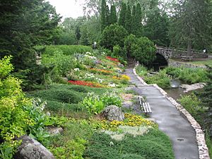
- It crosses Parc des Moulins, where the old zoo was.
- It flows through urban areas and along the edge of the Orsainville neighborhood.
- It goes through a green area, crossing Autoroute 73.
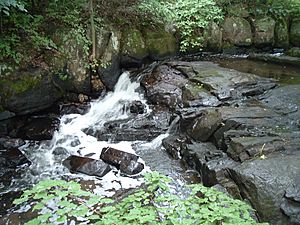
- It flows southwest, going through a long area with rapids in the Neufchâtel sector.
- It then flows southeast through Parc de l'Escarpement and an industrial park.
- Finally, it flows southeast through the Duberger area.
The Berger River ends by flowing into the Saint-Charles River. From this point, the water flows for about 8.3 kilometers (5.2 miles) along the Saint-Charles River.
River History
The name "Rivière du Berger" has been used since the time of New France. On a map from 1688, the name "Rivière du Berger" was clearly shown. Until the 1960s, the river's path stayed mostly natural. The areas around it were not built up.
In 1973, when Autoroute 740 was built, parts of the Berger River's path were changed.
River Name
The name "Rivière du Berger" is connected to the Du Berger area. The last part of the river flows through this area. The name "Rivière du Berger" became official on December 5, 1968. This was done by the Commission de toponymie du Québec, which names places in Quebec.
River Health and Protection
Most of the water pollution in the Berger River comes from city areas. Near where the Berger River meets the Saint-Charles River, the water quality is not very good. There are many bacteria, and too much phosphorus, aluminum, and other materials.
However, the water quality upstream (closer to the source) is much better. The water there is usually good enough for swimming. But near the old zoo, there was some bacteria pollution. This was because of water birds in the river. Studies of fish show that different types of brook trout live upstream and downstream of the old zoo site.
Some parts of the river banks are protected. This is part of the Saint-Charles and Berger rivers linear park.
Related Articles
 | Percy Lavon Julian |
 | Katherine Johnson |
 | George Washington Carver |
 | Annie Easley |


