Robertsville, Ohio facts for kids
Quick facts for kids
Robertsville, Ohio
|
|
|---|---|

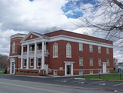
Church next to graveyard in Robertsville
|
|

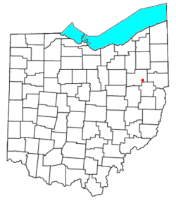
Location of Robertsville, Ohio
|
|
| Country | United States |
| State | Ohio |
| County | Stark |
| Township | Paris |
| Elevation | 1,083 ft (330 m) |
| Population
(2020)
|
|
| • Total | 293 |
| Time zone | UTC-5 (Eastern (EST)) |
| • Summer (DST) | UTC-4 (EDT) |
| ZIP code |
44670
|
| GNIS feature ID | 2628961 |
Robertsville is a small community in Ohio, United States. It is known as an unincorporated community and a census-designated place. This means it's a specific area that the government counts for population, but it doesn't have its own city government.
Robertsville is located in Stark County, within Paris Township. It has its own post office with the ZIP code 44670. The community is situated along U.S. Route 30, a major road, between the towns of East Canton and Minerva. It is also part of the Minerva Local School District. In 2020, the population of Robertsville was 293 people.
History of Robertsville
Robertsville was officially established in 1842. It was planned out by a person named Joseph Robard, and the community was named after him. Sometimes, it was also called Robardsville. The post office in Robertsville has been open and serving the community since 1862.
See also
 In Spanish: Robertsville (Ohio) para niños

