Rock Island, Oklahoma facts for kids
Quick facts for kids
Rock Island, Oklahoma
|
|
|---|---|

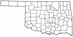
Location of Rock Island, Oklahoma
|
|
| Country | United States |
| State | Oklahoma |
| County | Le Flore |
| Area | |
| • Total | 12.23 sq mi (31.68 km2) |
| • Land | 12.17 sq mi (31.53 km2) |
| • Water | 0.06 sq mi (0.16 km2) |
| Elevation | 502 ft (153 m) |
| Population
(2020)
|
|
| • Total | 717 |
| • Density | 58.90/sq mi (22.74/km2) |
| Time zone | UTC-6 (Central (CST)) |
| • Summer (DST) | UTC-5 (CDT) |
| FIPS code | 40-63600 |
| GNIS feature ID | 2412560 |
Rock Island is a small town in Le Flore County, Oklahoma, in the United States. It is part of the Fort Smith, Arkansas-Oklahoma area, which is a larger group of towns and cities. In 2020, about 717 people lived there. This was a small increase from the 646 people counted in 2010.
Contents
History of Rock Island
How Rock Island Started
Rock Island began because of railroads. In 1886, a railway called the Fort Smith and Southern Railway built tracks through the area. The next year, these tracks were sold to another company, the St. Louis and San Francisco Railroad, also known as "the Frisco."
Then, in 1903–1904, the Midland Valley Railroad built another set of tracks. These new tracks crossed the Frisco line. A settlement grew up where the two railroads met. It was first called Maney Junction.
Naming the Town
A post office opened in this new settlement on February 1, 1905. It was named Rock Island. People believe it was named after Rock Island, Illinois, a city far away. At that time, the area was part of the Choctaw Nation, a Native American territory.
Becoming an Official Town
Rock Island started the process to become an official town in 1989. However, it took a long time for this to happen. The County Commissioners finally approved Rock Island as an official town in 2004.
Geography of Rock Island
Where Rock Island is Located
Rock Island is located in eastern Oklahoma. It is about 13 miles (21 kilometers) northeast of a town called Poteau.
Roads and Water
The town is on Oklahoma State Highway 112. This highway also connects to Oklahoma State Highway 120 right in Rock Island.
The town covers an area of about 12.2 square miles (31.6 square kilometers). Most of this area is land, about 12.1 square miles (31.5 square kilometers). A very small part, about 0.1 square miles (0.16 square kilometers), is water.
Economy of Rock Island
How People Make a Living
For a long time, Rock Island's economy mostly depended on farming. This means many people worked in agriculture, growing crops or raising animals.
Today, many people who live in Rock Island travel to other towns for work. They might commute to nearby places like Poteau or Fort Smith to find jobs.
Railroad Tunnel Near Rock Island
Jenson Tunnel
Just northeast of Rock Island, there is a special place called Jenson Tunnel. This tunnel is unique because it is the only known railroad tunnel in all of Oklahoma!
The Frisco Railway built the Jenson Tunnel in 1885. It is quite long, stretching about 1,180 feet (360 meters). Today, the Kansas City Southern railroad uses this tunnel for its trains.
Population of Rock Island
Changes Over Time
The number of people living in Rock Island has changed over the years. Here's a look at the population counts from different years:
| Historical population | |||
|---|---|---|---|
| Census | Pop. | %± | |
| 1990 | 478 | — | |
| 2000 | 709 | 48.3% | |
| 2010 | 646 | −8.9% | |
| 2020 | 717 | 11.0% | |
| U.S. Decennial Census | |||
Who Lives in Rock Island
According to the 2000 census, there were 709 people living in Rock Island. Most of the people were White, and some were Native American or from other backgrounds.
The average age of people in Rock Island in 2000 was 36 years old. About 29% of the population was under 18 years old.
See also
 In Spanish: Rock Island (Oklahoma) para niños

