Rock O' the Range Bridge facts for kids
Quick facts for kids Rock O' the Range Bridge |
|
|---|---|
 |
|
| Coordinates | 44°07′20″N 121°17′13″W / 44.122345°N 121.286861°W |
| Carries | Bowery Lane |
| Crosses | Swalley Canal |
| Maintained by | Local Homeowners |
| Characteristics | |
| Design | Covered |
| Total length | 42 feet (13 m) |
| Clearance above | 12.3 feet (3.7 m) |
| History | |
| Constructed by | Maurice Olson |
| Construction end | 1963 |
|
Rock O' the Range Bridge
|
|
 |
|
| Nearest city | Bend, Oregon |
| Architectural style | King Post Truss |
| MPS | Oregon Covered Bridges TR |
| NRHP reference No. | 79002054 |
| Added to NRHP | 29 November 1979 |
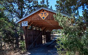
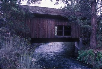
The Rock O' the Range Bridge is a special covered bridge in Oregon, U.S. It is also known as the Swalley Canal Bridge. You can find it north of Bend, near U.S. Route 97. This bridge is unique because it is the only covered bridge on the east side of the Cascade Range in Oregon. It is also one of the few covered bridges in the state that is privately owned.
Contents
Building the Rock O' the Range Bridge
The story of the Rock O' the Range Bridge began with a man named William Bowen. He owned land north of Bend. To reach his property, he needed a way to cross the Swalley Canal.
How the Bridge Was Designed
William Bowen got the idea for his bridge from another famous bridge. He was inspired by the Goodpasture Bridge in Lane County. He wanted a similar covered design for his own crossing.
Who Built the Bridge?
Mr. Bowen hired a builder named Maurice Olson to construct the bridge. Maurice Olson finished building the bridge in 1963. The cost to build this special bridge was $4,500 back then.
Bridge Challenges and Maintenance
Over the years, the Rock O' the Range Bridge has faced some challenges. Very tall vehicles have sometimes hit the top parts of the bridge. This has caused damage to the entrance boards and roof supports. The bridge has a clearance of about 9 feet (2.7 meters), which is quite low. This means taller trucks or vehicles can sometimes hit it if they are not careful.
 | Jackie Robinson |
 | Jack Johnson |
 | Althea Gibson |
 | Arthur Ashe |
 | Muhammad Ali |

