Swalley Irrigation District facts for kids

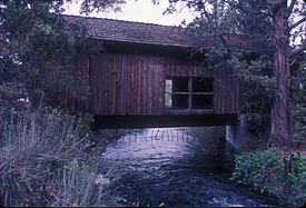
Bridge over the Swalley Canal
|
|
| Predecessor | Deschutes Reclamation and Irrigation Company (DRIC) (1899) |
|---|---|
| Formation | September 1, 1899 |
| Founder | (DRIC, 1899) Eight families of homesteaders including two families named Swalley |
| Type | Municipal Corporation - ORS 545 |
| Legal status | Active local government duly organized under ORS 545 |
| Purpose | Water distribution |
| Headquarters | Bend, Oregon |
|
Region
|
Central Oregon |
| Methods | Canal & Pipeline Conveyance |
The Swalley Irrigation District helps farmers and others get water from the Deschutes River near Bend, in Oregon. This water is sent through a big network of pipes and canals. This system started way back in 1899. It's a "closed system," meaning the water goes in at one end and is used up by customers, without flowing back into the river. One special thing about it is that the only covered bridge east of the Cascade Range in Oregon crosses the Swalley Canal!
The district uses about 82 cubic feet of water per second (CFS) during the irrigation season, which is from April to October. Over the years, the district has saved a lot of water. This means more water stays in the river. More water in the river is good for fish like redband trout and other animals. The district also uses the water to make clean electricity.
History of the District
The Swalley Irrigation District started in 1899. It was first called the Deschutes Reclamation and Irrigation Company (DRIC). In 1994, the people who owned the company decided to change it into an official irrigation district. They chose the name "Swalley" after two families who lived there. These families, named Swalley, helped start and run the first company. One of the Swalleys even became the project leader. He helped build the special channels, called flumes, that carried the water.
How the District Works
The Swalley Irrigation District covers about 17,000 acres (6,880 hectares). It is about 14 miles (23 km) long and 4 miles (6 km) wide. The water enters the system from the North Canal Dam on the Deschutes River in Bend. This spot is about 3,558 feet (1,084 meters) above sea level. The water then flows downhill through pipes and open canals to farms. Some farms are as much as 400 feet (122 meters) lower than the dam.
The main canal, called the Swalley Canal, is 13 miles (21 km) long. It has 15 miles (24 km) of smaller side canals. These canals deliver water to about 700 customers north of Bend. The district is mostly located between Highway 20 on the west and Highway 97 on the east.
For the first 5.1 miles (8.2 km), the water flows through large pipes under pressure. In 2010, the district finished putting pipes in this section. They also added a hydroelectric plant that makes 0.75 megawatts of electricity. This plant makes enough power for about 375 homes and businesses. The district earns about $160,000 to $190,000 each year by selling this electricity. Grants helped pay for most of the $14.5 million cost.
The canal continues for another 7 miles (11 km) past the power plant. It is a closed system, so no water flows back into the Deschutes River. Special screens at the start of the canal stop fish from getting into the pipes.
Most customers in the district get enough water to irrigate about 6 acres (2.4 hectares). Common crops grown with this water include grass and alfalfa. Some customers also use the water for oats, shrubs, pine trees, wine grapes, and even school sports fields and parks.
Saving Water for the River
The district started changing its open canals into pipes in the early 2000s. This helps save water because pipes prevent leaks and water from evaporating into the air. The project in 2010 saved 28 cubic feet per second (0.79 cubic meters per second) of water. This meant the district's water use dropped to 84 cubic feet per second (2.38 cubic meters per second).
Saving water helps the Deschutes River. More water stays in the river, which is better for fish like the redband trout. Other piping projects in nearby areas also helped save water. The goal of groups like the Deschutes River Conservancy is to keep more water flowing in the river. Some homeowners did not want the canals to be piped, but the projects went ahead.
The Cool Bridge
An unusual covered bridge crosses the Swalley Canal about 2 miles (3 km) north of Bend. This bridge is called the Rock O' the Range Bridge. It is the only covered bridge in Oregon that is east of the Cascade Range mountains. Bowery Lane goes over the canal on this bridge.
A builder had the bridge built in 1963 so people could reach his new properties. The landowners in that area pay to keep the bridge in good condition. It is one of the few covered bridges built recently that was paid for by private citizens.
 | Claudette Colvin |
 | Myrlie Evers-Williams |
 | Alberta Odell Jones |

