Rock and Pillar Range facts for kids

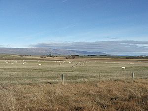
The Rock and Pillar Range is a group of tall hills found in the Maniototo area, which is inland Otago, New Zealand. The Taieri River starts in these hills and flows around them. It goes out across a flat area near Paerau, then almost turns back on itself at Waipiata, flowing along the other side through the Strath-Taieri. The town of Middlemarch is close to the Taieri River on the east side of the range, and Patearoa is to the northwest.
The Rock and Pillar Range is a special type of mountain range called a horst. This means it was formed when the land between two parallel faults (cracks in the Earth's crust) was pushed upwards. Because of this, the range has a very flat top, with steep cliffs, called escarpments, on both sides. A large wetland called the Great Moss Swamp is located on the flat top of the range.
A very unusual cloud often forms above these hills. This strange cloud, which is mostly still, is called the Taieri Pet by local people. It forms when strong north-westerly winds are forced to rise up over the Rock and Pillar Range. There's a public hut called Big Hut near the top of the range that people can use.
What Are the Highest Points?
The range gets its name from the interesting rock shapes that cover parts of it. The highest point is called Summit Peak or Summit Rock, which is about 1,450 metres (4,760 ft) tall. Other lower points include Stonehenge, at 1,380 metres (4,530 ft), and McPhee's Rock, at 1,013 metres (3,323 ft).
Animals and Plants
The Burgan Skink is a special lizard that lives only in the Rock and Pillar Range. It is considered nationally endangered, meaning it's at risk of disappearing forever. This skink is endemic to the area, which means it naturally lives nowhere else in the world.
 | Janet Taylor Pickett |
 | Synthia Saint James |
 | Howardena Pindell |
 | Faith Ringgold |

