Rocky Gully, Western Australia facts for kids
Quick facts for kids Rocky GullyWestern Australia |
|
|---|---|

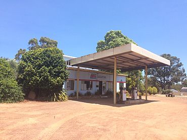
Rocky Gully General Store
|
|
| Established | 1951 |
| Postcode(s) | 6397 |
| Elevation | 243 m (797 ft) |
| Area | [convert: needs a number] |
| Location |
|
| LGA(s) | Shire of Plantagenet |
| State electorate(s) | Blackwood-Stirling |
| Federal Division(s) | O'Connor |
Rocky Gully is a small town in the Great Southern region of Western Australia. It is located along the Muirs Highway, about 8 kilometers from the Kent River.
Discover Rocky Gully
Rocky Gully is a small town found in the Great Southern area of Western Australia. This region is known for its beautiful landscapes and farming. The town sits along the Muirs Highway, which is an important road. It is also quite close to the Kent River, about 8 kilometers away.
How Rocky Gully Started
The story of Rocky Gully began in the 1930s. At that time, land in the area was divided into smaller pieces. This was done to prepare for new communities.
A New Community in 1951
By 1951, a small group of people had settled in Rocky Gully. This happened as part of a special plan called the War Service land settlement scheme. After World War II, this scheme helped soldiers who had returned home. It gave them land to start farms and new lives. The government officially recognized Rocky Gully as a townsite in 1951. This means it was formally named and marked on maps.
 | Lonnie Johnson |
 | Granville Woods |
 | Lewis Howard Latimer |
 | James West |


