Shire of Plantagenet facts for kids
Quick facts for kids Shire of PlantagenetWestern Australia |
|||||||||||||||
|---|---|---|---|---|---|---|---|---|---|---|---|---|---|---|---|

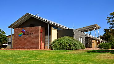
Plantagenet shire offices, 2018
|
|||||||||||||||

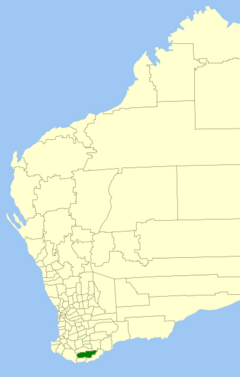
Location in Western Australia
|
|||||||||||||||
| Established | 1871 | ||||||||||||||
| Area | 4,792 km2 (1,850.2 sq mi) | ||||||||||||||
| Shire President | Chris Pavlovich | ||||||||||||||
| Council seat | Mount Barker | ||||||||||||||
| Region | Great Southern | ||||||||||||||
| State electorate(s) | Blackwood-Stirling | ||||||||||||||
| Federal Division(s) | O'Connor | ||||||||||||||
 |
|||||||||||||||
| Website | Shire of Plantagenet | ||||||||||||||
|
|||||||||||||||
The Shire of Plantagenet is a special local area in Western Australia. It's like a small government that helps manage services for the people living there. The main town where it's run from is Mount Barker. This town is about 360 kilometers (224 miles) south of Perth and 50 kilometers (31 miles) north of Albany.
The Shire of Plantagenet covers a large area of about 4,792 square kilometers (1,850 square miles). It includes several communities like Narrikup, Rocky Gully, Kendenup, and Porongurup.
Contents
What the Shire is Known For
This area is famous for its farming. Farmers here grow wheat and canola. They also raise sheep for wool and meat, and beef cattle. You can find wine and olives grown here too.
Another important industry used to be silviculture, which is growing trees for wood. Large plantations of Tasmanian blue gums were common.
Fun Places to Visit
If you visit the Shire of Plantagenet, there are cool places to explore.
- The Porongurup Range and Stirling Range are beautiful mountain areas.
- You can visit a museum located in an old police station.
- There are also other old buildings from the early settlers, like St Werburgh's Chapel.
A Look at History
The Shire of Plantagenet has a long history. It started on January 24, 1871. Back then, it was called the Plantagenet Road District. It was one of 18 groups chosen to manage roads and other services in Western Australia.
Over time, things changed. On July 1, 1961, a new law was passed called the Local Government Act 1960. This law changed all the old "road districts" into "shires." That's how the Plantagenet Road District became the Shire of Plantagenet.
How the Shire is Organized
The Shire of Plantagenet is divided into five different areas called "wards." Each ward has people called councillors who are elected to represent their area. The person in charge of the whole Shire is called the Shire President. This person is chosen from among the councillors.
The five wards are:
- East Ward (has two councillors)
- Kendenup Ward (has one councillor)
- Rocky Gully/West Ward (has two councillors)
- South Ward (has one councillor)
- Town Ward (has three councillors)
Towns and Communities
Here are some of the towns and communities you can find in the Shire of Plantagenet. The numbers show how many people lived there according to the most recent Australian census.
| Locality | Population | Area | Map |
|---|---|---|---|
| Denbarker | 93 | [convert: needs a number] | |
| Forest Hill | 143 | [convert: needs a number] | |
| Kendenup | 1,062 | [convert: needs a number] | |
| Mount Barker | 2,855 | [convert: needs a number] | |
| Narrikup | 514 | [convert: needs a number] | |
| Perillup | 46 | [convert: needs a number] | |
| Porongurup | 342 | [convert: needs a number] | |
| Rocky Gully | 92 | [convert: needs a number] | |
| Stirling Range National Park * | 0 | 1,121.3 km2 (432.9 sq mi) | |
| Takalarup | 127 | [convert: needs a number] | |
| Woogenellup | 116 | [convert: needs a number] |
- ( * means this place is only partly inside the Shire of Plantagenet)
Important Buildings and Projects
The Shire of Plantagenet owns and runs the Great Southern Saleyards. This is a modern place where farmers can sell their livestock. It was built around 2002.
Near Mount Barker, there's a wind farm. It has three tall wind turbines that are 73 meters (240 feet) high. These turbines create electricity by using the wind. This electricity is then sold to the state power grid. It's a great example of using renewable energy to power the community.
Community Services
The Shire of Plantagenet provides many services to its residents, just like other local governments in Western Australia.
Waste Management
- Rubbish collection is handled by a company called Warren Blackwood Waste.
- There's a main rubbish tip south of Mount Barker on O'Neill Road.
- Smaller transfer stations, where you can drop off rubbish, are located in Kendenup, Porongurup, and Narrikup.
Emergency Services
- The Shire Office in Mount Barker has Ranger Services. These rangers help with things like animal control and local rules.
- There's also a Community Emergency Services Manager (CESM). This person helps local bushfire brigades and the State Emergency Service (SES) unit.
- Bushfire brigades are groups of volunteers who help fight fires. They are located in many communities across the Shire.
- The Shire also works with the community through groups like the Local Emergency Management Committee and the Roadwise Committee. These groups help keep people safe and roads in good condition.
Historical Places
As of 2023, there are 74 places in the Shire of Plantagenet that are listed as important historical sites. Six of these are on the State Register of Heritage Places, which means they are very important to the history of Western Australia.
 | Dorothy Vaughan |
 | Charles Henry Turner |
 | Hildrus Poindexter |
 | Henry Cecil McBay |

