Rodborough facts for kids
Rodborough is a lovely area in Gloucestershire, South West England. It's like a small local community with its own council, known as a civil parish. You can find Rodborough just south of the town of Stroud and north of Nailsworth. It's also north-west of the village of Minchinhampton.
Rodborough includes several smaller places like Bagpath, Butterrow, Kingscourt, Lightpill, and Rooksmoor. It's also right next to Dudbridge, which is a part of Stroud. In 2011, about 5,334 people lived here.
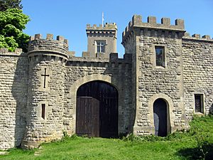
Rodborough village is built on a hill, giving it great views. It's very close to Rodborough Common, which is a big open space where people love to walk and enjoy nature. Most of this common land was given to the National Trust in 1937. This gift came from Thomas Bainbrigge Fletcher, who was an entomologist (someone who studies insects). To help keep the common beautiful, £700 was raised to pay for its care. On the common, there's also a cool building called Rodborough Fort. It was built in 1761 as a "folly," which means it was built for fun or decoration, not for defense. Today, it's a private home.
Fun Things to Do in Rodborough
Rodborough Common is a very special place for nature. It's called a Site of Special Scientific Interest because it has important plants and animals.
The area has two primary schools where younger kids learn. There are also several public houses (pubs) and a large hotel called The Bear of Rodborough Hotel. For the community, there's a hall where events happen. You can also find the historic Winstones Ice Cream Factory here, making delicious treats!
Rodborough has a lively Christian community. People attend the Church of England parish church of St. Mary Magdalene or the Rodborough Tabernacle United Reformed Church. There are also many clubs and groups, like a football club, a Scout group for adventures, and a group for mothers and toddlers.
If you want to know what's happening, you can read the local newspaper, the Stroud News & Journal. The local council also puts out a newsletter four times a year called The Commoner. For kids, Rodborough has several playgrounds, and the community hall hosts a youth club every Friday night.
How Rodborough is Run
Rodborough has its own local government. It is looked after by the Rodborough Parish Council, which handles local matters. It's also part of the Stroud District Council and the Gloucestershire County Council, which manage bigger services for the whole area.
Before 1974, much of Rodborough was part of the Stroud Urban District Council. Today, it's still considered part of the Stroud urban area, along with Stroud and Cainscross.
There's also an "electoral ward" with the same name, Rodborough. This is a specific area used for voting in local elections. The population of this ward was 4,543 in 2011.
 | Tommie Smith |
 | Simone Manuel |
 | Shani Davis |
 | Simone Biles |
 | Alice Coachman |


