Rolesville, North Carolina facts for kids
Quick facts for kids
Rolesville, North Carolina
|
|
|---|---|

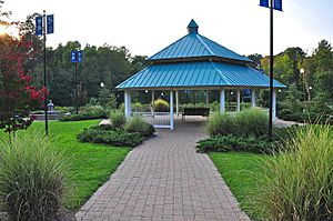
Main Street Park
|
|

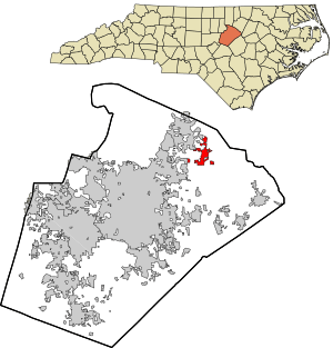
Location in Wake County and the state of North Carolina.
|
|
| Country | United States |
| State | North Carolina |
| County | Wake |
| Named for | William H. Roles |
| Area | |
| • Total | 6.12 sq mi (15.84 km2) |
| • Land | 6.11 sq mi (15.82 km2) |
| • Water | 0.01 sq mi (0.02 km2) |
| Elevation | 410 ft (120 m) |
| Population | |
| • Total | 9,475 |
| • Density | 1,551.24/sq mi (598.97/km2) |
| Time zone | UTC-5 (Eastern (EST)) |
| • Summer (DST) | UTC-4 (EDT) |
| ZIP code |
27571
|
| Area code(s) | 919 984 |
| FIPS code | 37-57640 |
| GNIS feature ID | 2407237 |
| Website | http://rolesvillenc.gov/ |
Rolesville is a town located in the northeastern part of Wake County, North Carolina. It is a suburb of Raleigh, which is the capital city of North Carolina. Rolesville is special because it is the second oldest town in Wake County. In 2020, about 9,475 people lived there.
Contents
A Look Back in Time
Rolesville was named after William H. Roles. He bought land in this area in the early 1800s and decided to settle there. Under his leadership, the town officially became a town in 1837. It was also an important stop for stagecoaches, which were like old-fashioned buses.
Around the same time, the Rolesville Baptist Church was started, and William H. Roles was also involved in its creation. The North Carolina Legislature officially made Rolesville a town on January 18, 1837.
Where is Rolesville?
Rolesville covers an area of about 15.82 square kilometers (or 6.11 square miles) of land. There is a tiny bit of water, about 0.02 square kilometers.
The town is also known for something cool in geology! It's the namesake of the Rolesville diorite Batholith. This is a huge underground rock formation, sometimes called the Rolesville Pluton. You can see parts of this rock formation sticking out of the ground in and around the town.
People of Rolesville
The number of people living in Rolesville has changed a lot over the years. Here's how the population has grown:
| Historical population | |||
|---|---|---|---|
| Census | Pop. | %± | |
| 1880 | 115 | — | |
| 1890 | 150 | 30.4% | |
| 1900 | 155 | 3.3% | |
| 1910 | 170 | 9.7% | |
| 1950 | 288 | — | |
| 1960 | 358 | 24.3% | |
| 1970 | 533 | 48.9% | |
| 1980 | 381 | −28.5% | |
| 1990 | 572 | 50.1% | |
| 2000 | 907 | 58.6% | |
| 2010 | 3,786 | 317.4% | |
| 2020 | 9,475 | 150.3% | |
| 2022 (est.) | 10,661 | 181.6% | |
| U.S. Decennial Census | |||
Rolesville's Diverse Community
The 2020 United States census showed that 9,475 people lived in Rolesville. These people made up 2,204 households, with 2,054 of those being families.
The town is home to people from many different backgrounds. Here's a quick look at the different groups in Rolesville:
| Group | Number | Percentage |
|---|---|---|
| White (not Hispanic) | 5,743 | 60.61% |
| Black or African American (not Hispanic) | 2,096 | 22.12% |
| Native American | 14 | 0.15% |
| Asian | 327 | 3.45% |
| Pacific Islander | 4 | 0.04% |
| Other/Mixed | 455 | 4.8% |
| Hispanic or Latino | 836 | 8.82% |
Fun Places to Visit
Rolesville has several parks and recreation areas where people can have fun and enjoy nature. These include:
- Main Street Park
- Redford Place Park
- Mill Bridge Nature Park
- Rolesville Community Center
Learning in Rolesville
The town has several schools for students of all ages:
- Rolesville Elementary School
- Rolesville Middle School
- Rolesville High School
- Sanford Creek Elementary School
- Thales Academy Junior High/High School - Rolesville
See also
 In Spanish: Rolesville para niños
 | William Lucy |
 | Charles Hayes |
 | Cleveland Robinson |

