Roquesteron facts for kids
Quick facts for kids
Roquesteron
|
||
|---|---|---|
 |
||
|
||
| Country | France | |
| Region | Provence-Alpes-Côte d'Azur | |
| Department | Alpes-Maritimes | |
| Arrondissement | Nice | |
| Canton | Roquesteron | |
| Intercommunality | Vallée de l'Estéron | |
| Area
1
|
6.47 km2 (2.50 sq mi) | |
| Population
(2008)
|
539 | |
| • Density | 83.31/km2 (215.8/sq mi) | |
| Demonym(s) | Roquestéronnais | |
| Time zone | UTC+01:00 (CET) | |
| • Summer (DST) | UTC+02:00 (CEST) | |
| INSEE/Postal code |
06106 /06910
|
|
| Elevation | 270–1,040 m (890–3,410 ft) (avg. 340 m or 1,120 ft) |
|
| 1 French Land Register data, which excludes lakes, ponds, glaciers > 1 km2 (0.386 sq mi or 247 acres) and river estuaries. | ||
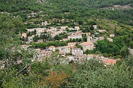
Roquesteron is a small town, also called a commune, located in the south of France. It is part of the Provence-Alpes-Côte d'Azur region and the Alpes-Maritimes department. This charming place is known for its beautiful natural surroundings.
Contents
Discover Roquesteron
Roquesteron is a lovely commune in France. It has a population of about 539 people, based on numbers from 2008. The people who live here are called Roquestéronnais.
Where is Roquesteron?
Roquesteron is located in the southeastern part of France. It is in the Alpes-Maritimes department. This area is famous for its stunning landscapes, which include mountains and valleys. The town is situated at an elevation of about 340 meters (1,115 feet) above sea level.
What is a Commune?
In France, a commune is like a local government area. It is the smallest division of local government. Think of it as a town or a village with its own local council. Roquesteron is one of many communes in France.
Local Leadership
Every commune has a mayor who leads the local government. For Roquesteron, the mayor from 2008 to 2014 was André Roumagnac. The mayor helps manage the town and its services for the people living there.
Geography and Nature
Roquesteron covers an area of about 6.47 square kilometers (2.5 square miles). The land around Roquesteron varies quite a bit in height. The lowest point is 270 meters (886 feet) above sea level. The highest point reaches 1,040 meters (3,412 feet). This difference in height means the area has diverse natural environments.
See also
 In Spanish: Roquestéron para niños


