Roubion facts for kids
Quick facts for kids
Roubion
|
||
|---|---|---|
|
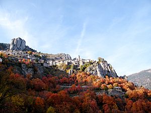
The village of Roubion in Autumn
|
||
|
||
| Country | France | |
| Region | Provence-Alpes-Côte d'Azur | |
| Department | Alpes-Maritimes | |
| Arrondissement | Nice | |
| Canton | Tourrette-Levens | |
| Intercommunality | Métropole Nice Côte d'Azur | |
| Area
1
|
27.26 km2 (10.53 sq mi) | |
| Population
(Jan. 2021)
|
Lua error in Module:Wd at line 1,575: attempt to index field 'wikibase' (a nil value). | |
| Time zone | UTC+01:00 (CET) | |
| • Summer (DST) | UTC+02:00 (CEST) | |
| INSEE/Postal code |
06110 /06420
|
|
| Elevation | 840–2,488 m (2,756–8,163 ft) | |
| 1 French Land Register data, which excludes lakes, ponds, glaciers > 1 km2 (0.386 sq mi or 247 acres) and river estuaries. | ||
Roubion is a small town or village, also known as a commune, located in the south of France. It is found in the beautiful region called Provence-Alpes-Côte d'Azur. This area is known for its stunning landscapes and sunny weather.
Contents
Where is Roubion Located?
Roubion is part of the Alpes-Maritimes department. This department is famous for its mountains and its coastline along the Mediterranean Sea. Even though it's in a mountainous area, Roubion is still considered to be in the southern part of France.
Understanding Communes and Departments
In France, a commune is the smallest unit of local government. Think of it like a town or a village. A department is a larger area, similar to a county or a province in other countries. These help organize how France is governed.
Roubion's Elevation and Size
Roubion is located in the mountains. Its lowest point is about 840 meters (2,756 feet) above sea level. The highest point reaches 2,488 meters (8,163 feet). The total area of the commune is about 27.26 square kilometers (10.53 square miles). This shows it's a place with varied terrain, from valleys to high peaks.
Images for kids
See also
 In Spanish: Roubion para niños


