
Roullée facts for kids
Quick facts for kids
Roullée
|
|
|---|---|
 |
|

Roullée
Location in France

Roullée
Location in Pays de la Loire
|
|
| Country | France |
| Region | Pays de la Loire |
| Department | Sarthe |
| Arrondissement | Mamers |
| Canton | Mamers |
| Area
1
|
19.93 km2 (7.70 sq mi) |
| Population
(2006)
|
255 |
| • Density | 12.795/km2 (33.14/sq mi) |
| Time zone | UTC+01:00 (CET) |
| • Summer (DST) | UTC+02:00 (CEST) |
| INSEE/Postal code |
72258 /72600
|
| Elevation | 136–193 m (446–633 ft) |
| 1 French Land Register data, which excludes lakes, ponds, glaciers > 1 km2 (0.386 sq mi or 247 acres) and river estuaries. | |
Roullée was a small village in France. It was located in the western part of the country. This former commune was part of the Pays de la Loire region. It was also found in the Sarthe department. In 2015, Roullée joined with other villages to form a new, larger commune called Villeneuve-en-Perseigne.
Contents
About Roullée
Roullée was a quiet place with a small number of people living there. In 2006, about 255 residents called Roullée home. The village was known for its peaceful countryside.
Where is Roullée?
Roullée was situated in the western part of France. It was part of the Sarthe department. This area is known for its green landscapes and charming villages. The nearest larger town was Mamers.
Becoming Part of Villeneuve-en-Perseigne
In 2015, Roullée merged with several other communes. This merger created a new, bigger commune named Villeneuve-en-Perseigne. This happens sometimes in France to make local government more efficient. It means that Roullée is no longer a separate commune on its own.
Geography of Roullée
The area around Roullée had varied land. The lowest point was 136 meters (about 446 feet) above sea level. The highest point reached 193 meters (about 633 feet). This shows that the village was located in a slightly hilly region.
Size of the Area
The total area of Roullée was 19.93 square kilometers. This is about 7.7 square miles. It was a moderately sized rural commune before it merged.
Images for kids
-
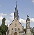
The Church of the Trinity and war memorial in Roullée.
See also
 In Spanish: Roullée para niños
