Rumford, Falkirk facts for kids
Quick facts for kids Rumford |
|
|---|---|
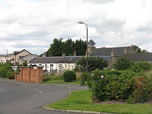
 Nicolton Road, Rumford |
|
| Population | 810 (2020) |
| OS grid reference | NS934771 |
| Civil parish |
|
| Council area | |
| Lieutenancy area |
|
| Country | Scotland |
| Sovereign state | United Kingdom |
| Post town | FALKIRK |
| Postcode district | FK2 |
| Dialling code | 01324 |
| EU Parliament | Scotland |
| UK Parliament |
|
| Scottish Parliament |
|
| Website | falkirk.gov.uk |
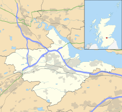
Rumford is a small village located in Scotland, within the Falkirk council area. It sits between the villages of Maddiston and Brightons.
Growing Over Time
Rumford has seen a lot of growth, especially in the late 1990s and early 2000s. This means more and more people have moved to the village.
Population Changes
The number of people living in Rumford has increased quite a bit over the years.
- In 1991, about 275 people lived there.
- By 2001, the population grew to 421 residents.
- In 2011, it nearly doubled again to 884 people.
This shows how much the village has expanded in a relatively short time!
See also
 In Spanish: Rumford para niños
Black History Month on Kiddle
Famous African-American Scientists:
 | Ernest Everett Just |
 | Mary Jackson |
 | Emmett Chappelle |
 | Marie Maynard Daly |

All content from Kiddle encyclopedia articles (including the article images and facts) can be freely used under Attribution-ShareAlike license, unless stated otherwise. Cite this article:
Rumford, Falkirk Facts for Kids. Kiddle Encyclopedia.

