
Runcorn to Latchford Canal facts for kids
Quick facts for kids Runcorn to Latchford Canal |
|
|---|---|

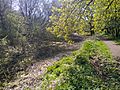
A small section between Walton Railway Bridges and the A5060 road still holds water.
|
|
| Specifications | |
| Maximum boat length | 70 ft 0 in (21.34 m) |
| Maximum boat beam | 14 ft 9 in (4.50 m) |
| Status | Closed |
| History | |
| Original owner | Mersey and Irwell Navigation Company |
| Date of act | 1720 |
| Date of first use | 1804 |
| Date closed | 1890s |
The Runcorn to Latchford Canal was an important waterway in England. It was also known by other names like the Old Quay Canal or the "Black Bear Canal." This canal stretched from Runcorn in Cheshire all the way to the Latchford area of Warrington. It linked the Mersey and Irwell Navigation to the River Mersey at Runcorn.
Contents
Building and Using the Canal
The Runcorn to Latchford Canal was built to help boats avoid shallow parts of the River Mersey near Fiddlers Ferry. It was about 7 miles (11 km) long. The canal ended near the center of Runcorn. It cost a lot of money to build, around £48,000.
At Latchford, the canal joined the Mersey River. There was a lock there, which is like a water elevator for boats. A dock was also built at Runcorn, which became part of the Port of Runcorn. The canal opened in July 1804.
Changes Over Time
In 1844, the Bridgewater Canal Company bought the Runcorn to Latchford Canal. They did not spend much money to keep it in good shape. Because of this, the canal slowly got worse.
Later, in the 1890s, the Manchester Ship Canal Company bought the canal. They really wanted this canal because their new, much larger ship canal would use some of its path. When the Manchester Ship Canal was built, much of the western part of the Runcorn to Latchford Canal disappeared. This included the docks in Runcorn.
However, the eastern part of the canal was kept. The section between Twenty Steps Bridge and Latchford Lock remained. A new lock, called Twenty Steps Lock, was built. This lock helped boats move between the old canal and the new ship canal. This part of the canal was used to bring animal hides from Argentina to tanneries (places that make leather) in Howley. This trade continued until the 1960s. This section was known as the Black Bear Canal. It stopped being used after the tanneries closed down.
How the Canal Got Water
The canal had locks at both ends that lowered boats into the river. Since the canal didn't have a natural water source, it needed a way to get water. Water was lost every time a boat went through a lock.
To solve this, a feeder was built. This feeder brought water from the Mersey and Irwell Navigation. The water crossed the Mersey in an aqueduct, which was also a footbridge. It then flowed along the banks of the Mersey to Latchford Lock. The water entered the canal just south of this lock. When the Black Bear Canal section was created, Twenty Steps Lock also connected to the ship canal, so the water supply system was kept. Latchford Lock was often called Manor Lock after the ship canal was built.
Bringing the Locks Back to Life
In 2015, a group called the Runcorn Locks Restoration Society started a campaign called "Unlock Runcorn." Their goal is to reopen the series of locks in Runcorn's Old Town.
The society believes that if the locks are reopened, more boats will use the canal. This could bring many good things to the area. It could help the local economy, create more fun activities, and benefit the community.
Exploring the Canal's Path Today
The map shows how the canal looked in the 1880s. It also shows where the Manchester Ship Canal later cut through it. It also shows features like Twenty Steps Lock, which connected a part of the old canal to the ship canal.

You can still find parts of the canal today. Some traces exist in Wigg Island and in Moore Nature Reserve. The canal's path is now part of a "Linear Park" that runs next to the River Mersey at Lower Walton. You can clearly see it when looking west from Chester Road (A5060) on the bridge over the Mersey.
Further away, you can see the "Twelve Arches Bridge." Arch number 3 of this bridge (counting from south to north) goes over where the canal used to be. The canal basin, which is mostly dried out, can be followed west from the bridge towards Moore Nature Reserve and then Runcorn.
The canal goes east under the A5060 road. It then joins the Manchester Ship Canal at Latchford Locks. After that, it appears again in Stockton Heath. It passes under the London Road Swing Bridge (A49) and then under Loushers Lane Bridge. Finally, it goes under Knutsford Road near where the Black Bear Public House used to be. The canal's path then goes a short distance before ending and rejoining the River Mersey near Kingsway North Bridge.
The Wigg Island nature reserve is 57 acres (23 ha) big and opened in April 2002. It is named after the Wigg Chemical Works, which started in the 1860s. This factory made chemicals and even produced mustard gas during the Second World War. It closed in the 1960s.
When the canal was working, a big problem was that acidic waste from the factory would leak into the water. To fix this, a special filter system was built. Water now passes through a channel filled with limestone. This makes sure the water in the 600-yard (550 m) long section of canal that crosses the site is safe for wildlife.
Images for kids
-
The canal at Moore Nature Reserve

