
Ruwer-Hochwald-Radweg facts for kids


The Ruwer-Hochwald-Radweg is an exciting bike trail. It connects the beautiful Moselle valley with the Hunsrück region. This path stretches from the historic city of Trier all the way to Hermeskeil in Rhineland-Palatinate, Germany. It's about 48 km (29.8 mi) long, offering a great adventure for cyclists!
Contents
What Makes This Bike Path Special?
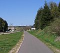
The Ruwer-Hochwald-Radweg is unique because it follows an old railway line. This means the path is mostly flat or has gentle slopes, making it easy and fun for everyone. You won't find many steep hills here!
Journey Through Towns and Nature
As you cycle along, you'll pass through charming towns and lovely natural areas. The path takes you through:
- Trier-Ruwer
- Mertesdorf
- Kasel
- Waldrach
- Sommerau
- Gusterath-Tal
- Pluwigerhammer
- Hinzenburg
- Burg Heid
- Hentern
- Zerf
- Niederkell
- Kell am See
- Reinsfeld
- Hermeskeil
Each section offers something new to see, from green forests to open fields.
How Long Are the Sections?
The total length of the trail is about 48 km (29.8 mi). Here's a quick look at how long each part is:
- Trier-Ruwer to Waldrach: 5.8 km (3.6 mi)
- Waldrach to Pluwigerhammer: 7.7 km (4.8 mi)
- Pluwigerhammer to Burg Heid: 6 km (3.7 mi)
- Burg Heid to Zerf: 5.6 km (3.5 mi)
- Zerf to Niederkell: 5.4 km (3.4 mi)
- Niederkell to Kell am See: 4 km (2.5 mi)
- Kell am See to Reinsfeld: 7 km (4.3 mi)
- Reinsfeld to Hermeskeil: 6.3 km (3.9 mi)
It's a great way to explore the region on your bike!
Images for kids
-
Bicycle way in Reinsfeld
