Sabaneta, Antioquia facts for kids
Quick facts for kids
Sabaneta, Antioquia
|
|||
|---|---|---|---|
|
Municipality and town
|
|||
 |
|||
|
|||

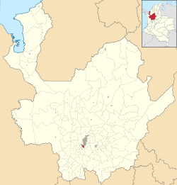
Location of the municipality and town of Sabaneta, Antioquia in the Antioquia Department of Colombia
|
|||
| Country | |||
| Department | |||
| Founded | 1903 | ||
| Area | |||
| • Municipality and town | 15 km2 (6 sq mi) | ||
| • Urban | 4.53 km2 (1.75 sq mi) | ||
| Elevation | 1,550 m (5,090 ft) | ||
| Population
(2018 census)
|
|||
| • Municipality and town | 82,375 | ||
| • Density | 5,490/km2 (14,200/sq mi) | ||
| • Urban | 70,401 | ||
| • Urban density | 15,541/km2 (40,250/sq mi) | ||
| Demonym(s) | Sabaneteño | ||
| Time zone | UTC-5 (Colombia Standard Time) | ||
| Area code(s) | 57 + 4 | ||
| Website | Official website: http://sabaneta.areadigital.gov.co/Pages/Inicio.aspx | ||
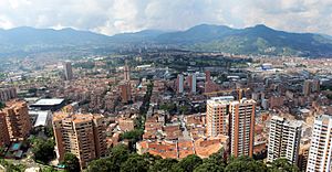
Sabaneta is a small and lively town in Colombia. It is a municipality located in the Aburrá Valley, which is part of the Antioquia department. Sabaneta is surrounded by other towns like La Estrella, Itagüí, and Envigado.
It is known for being the smallest municipality in Colombia, covering an area of just 15 square kilometers. People sometimes call it the "Model Municipality of Colombia" or the "Charming Little Valley" (Vallecito de Encanto). The name "Sabaneta" comes from a Spanish word meaning "little savannah." Many visitors come to Sabaneta on weekends to enjoy its fun entertainment spots.
History of Sabaneta
Sabaneta was first home to the Anacona indigenous people. They lived on the eastern side of the area, near the Pan de Azucar hill.
Around the year 1750, Spanish families started to settle here. Important families like the Montoya, Restrepo, and Vélez were among the first to build homes in this region.
Geography of Sabaneta
Sabaneta is located at the southern end of the Aburrá Valley. It is part of the larger Medellín Metropolitan Area, about 14 kilometers from the center of Medellín.
Most of Sabaneta, about 67% of its total area, is considered urban. This means it has many buildings and city-like areas.
Land and Hills
The land in Sabaneta changes a lot. Some parts are flat, while others have gentle hills or even steep slopes.
- The highest points include Piedras Blancas, which is 2,650 meters above sea level.
- Other notable hills are Cuchilla Santa Teresa (2,200 meters) and Los Gallinazos in Pan de Azúcar (1,800 meters).
Rivers and Streams
The main river in Sabaneta is the Medellín River. This river also forms part of its border with the town of Itagüí.
Several important streams flow into the Medellín River within Sabaneta. The La Doctora gorge is one of the most important. Other streams like Buenavista and La Honda also flow through the area. These streams help mark the borders of Sabaneta with nearby towns like Envigado.
See also
 In Spanish: Sabaneta (Colombia) para niños
 | John T. Biggers |
 | Thomas Blackshear |
 | Mark Bradford |
 | Beverly Buchanan |


