Saint-Benoît, Aude facts for kids
Quick facts for kids
Saint-Benoît
|
||
|---|---|---|

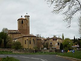
The church and surroundings in Saint-Benoît
|
||
|
||
| Country | France | |
| Region | Occitanie | |
| Department | Aude | |
| Arrondissement | Limoux | |
| Canton | La Haute-Vallée de l'Aude | |
| Intercommunality | Pyrénées Audoises | |
| Area
1
|
21.31 km2 (8.23 sq mi) | |
| Population
(Jan. 2021)
|
Lua error in Module:Wd at line 1,575: attempt to index field 'wikibase' (a nil value). | |
| Time zone | UTC+01:00 (CET) | |
| • Summer (DST) | UTC+02:00 (CEST) | |
| INSEE/Postal code |
11333 /11230
|
|
| Elevation | 406–766 m (1,332–2,513 ft) (avg. 450 m or 1,480 ft) |
|
| 1 French Land Register data, which excludes lakes, ponds, glaciers > 1 km2 (0.386 sq mi or 247 acres) and river estuaries. | ||
Saint-Benoît is a small village, known as a commune, located in the southern part of France. It is home to about 105 people, based on a 2017 count. This charming place is found in the Occitanie region, within the Aude department.
Contents
About Saint-Benoît
Saint-Benoît is a quiet and peaceful commune. A commune is like a small town or village with its own local government. It is part of the larger administrative structure of France. The village is known for its beautiful natural surroundings.
Where is Saint-Benoît?
Saint-Benoît is situated in the Aude department. This department is in the Occitanie region of France. Occitanie is a large area in the south of the country. The village is part of the Limoux arrondissement. An arrondissement is a type of administrative district.
How many people live there?
In 2017, the population of Saint-Benoît was 105 people. This makes it a very small community. The number of people living in a commune can change over time.
What is the land like?
The village is located at an elevation of about 450 meters (about 1,476 feet) above sea level. The lowest point in the commune is 406 meters (1,332 feet). The highest point reaches 766 meters (2,513 feet). The total area of Saint-Benoît is 21.31 square kilometers (about 8.23 square miles). This shows it has varied terrain, from lower valleys to higher hills.
Local Government
Like all communes in France, Saint-Benoît has its own local government. This government helps manage the daily life of the village.
Who is the Mayor?
The mayor of Saint-Benoît is Serge Bacave. He was elected to serve from 2014 to 2020. The mayor is the head of the local government. They are responsible for many things, like public services and local projects.
What is Intercommunality?
Saint-Benoît is part of a group called Pyrénées Audoises. This is an "intercommunality" group. It means several communes work together on shared projects. They might share services like waste collection or tourism promotion. This helps small communes achieve more together.
See also
 In Spanish: Saint-Benoît (Aude) para niños


