Saint-Cyr-l'École facts for kids
Quick facts for kids
Saint-Cyr-l'École
|
|
|---|---|

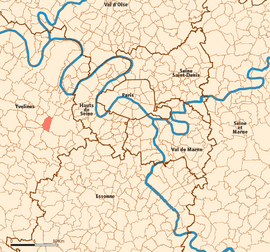
Location (in red) within Paris inner and outer suburbs
|
|
| Country | France |
| Region | Île-de-France |
| Department | Yvelines |
| Arrondissement | Versailles |
| Canton | Saint-Cyr-l'École |
| Intercommunality | CA Versailles Grand Parc |
| Area
1
|
5.01 km2 (1.93 sq mi) |
| Population
(Jan. 2021)
|
Lua error in Module:Wd at line 1,575: attempt to index field 'wikibase' (a nil value). |
| Time zone | UTC+01:00 (CET) |
| • Summer (DST) | UTC+02:00 (CEST) |
| INSEE/Postal code |
78545 /78210
|
| Elevation | 99–174 m (325–571 ft) (avg. 158 m or 518 ft) |
| 1 French Land Register data, which excludes lakes, ponds, glaciers > 1 km2 (0.386 sq mi or 247 acres) and river estuaries. | |
Saint-Cyr-l'École is a town located in the western suburbs of Paris, France. It is about 21.4 kilometers (13.3 miles) away from the very center of Paris. This town is known for its history, especially its connection to military education.
People who live in Saint-Cyr-l'École are called Saint-Cyriens.
Where is Saint-Cyr-l'École?
Saint-Cyr-l'École is found in the Versailles area. This area is west of the famous Park of Versailles. The town gets its name from Saint Cyricus.
A Famous Military School
For a long time, Saint-Cyr-l'École was home to a very important school. This was the École Spéciale Militaire de Saint-Cyr. It was a special training school for officers in the French army.
In 1945, the school moved to a place called Coëtquidan. The old buildings in Saint-Cyr-l'École are still used for education today. They are now home to the lycée militaire de Saint-Cyr. This is a military high school for students.
Images for kids
See also
In Spanish: Saint-Cyr-l'École para niños
 | Precious Adams |
 | Lauren Anderson |
 | Janet Collins |


