Saint-Régis River (Roussillon) facts for kids
Quick facts for kids Saint-Régis River |
|
|---|---|

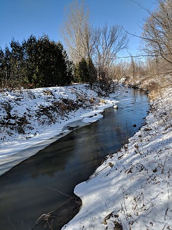
Saint-Régis River at Saint-Constant taken in November 2018
|
|
| Country | Canada |
| Province | Quebec |
| Region | Montérégie |
| MRC | Roussillon Regional County Municipality |
| Physical characteristics | |
| Main source | Various agricultural and urban streams, woodlands, wetlands and small bodies of water. Saint-Isidore 52 units? 45°17′35″N 73°41′03″W / 45.292965°N 73.684029°W |
| River mouth | St. Lawrence Seaway Sainte-Catherine 118 m (387 ft) 45°24′21″N 73°34′18″W / 45.40583°N 73.57166°W |
| Length | 19.2 km (11.9 mi) |
| Basin features | |
| Basin size | 97.2 km2 (37.5 sq mi) |
| Tributaries |
|
The Saint-Régis River is a river in Quebec, Canada. It flows into the St. Lawrence River. A "tributary" is a smaller river or stream that flows into a larger river. This river runs through the towns of Saint-Isidore, Saint-Constant, and Sainte-Catherine. These towns are located in the Roussillon Regional County Municipality, which is part of the Montérégie region in southwestern Quebec.
Contents
Where Does the Saint-Régis River Flow?
The Saint-Régis River is about 19.2 kilometres (11.9 mi) long. Its basin, the area of land that drains into it, covers about 92 kilometres (57.17 mi). The river begins from many small streams and ditches in farm areas near the village of Saint-Isidore. This area is northeast of Saint-Rémi and east of Mercier.
Surrounding Waterways
The Saint-Régis River is connected to other important waterways:
- To the north: The St. Lawrence Seaway and the St. Lawrence River.
- To the east: The Saint-Pierre River, which flows into the Saint-Régis.
- To the south and west: The Châteauguay River and its smaller branches.
How the River Gets Its Water
The river starts in a network of farm ditches and streams. These waterways collect water from the northern part of the Saint-Michel Plateau. This plateau helps separate the Saint-Régis River's water from other rivers like the rivière de l'Esturgeon.
The ground underground also helps feed the river. Water from the Adirondacks in the United States and other areas flows underground into the Saint-Régis watershed. The river also recharges the underground water supply, especially where the ground is permeable.
The River's Journey
From Saint-Isidore, the Saint-Régis River flows northeast through farmland. It runs alongside Highway 30 and Highway 730.
The river then goes under the Autoroute 30 bridge. It crosses a railroad and flows through Saint-Constant. Next, it crosses Route 132 in Sainte-Catherine. Here, it meets the Saint-Pierre River. The Saint-Régis River then flows for another 2.6 kilometres (1.6 mi) in Sainte-Catherine before reaching its end.
The river's mouth, where it empties, is very close to the Côte-Sainte-Catherine lock. This spot is directly across from the Lachine Rapids on the St. Lawrence River.
River Characteristics
The Saint-Régis River is usually about 4 metres (13 ft) wide. Its depth is around 20 centimetres (7.9 in) to 30 centimetres (12 in). The riverbanks are about 4 metres (13 ft) to 5 metres (16 ft) high. The riverbed is made of pebbles, gravel, sand, and fine dirt. The river flows gently along its path.
Over time, especially since the 1960s, the river's path has been changed. This was done to help with drainage in the area.
Understanding Floods
In early November, the area sometimes experiences heavy rain and snow. This can cause big floods. Once, 170 millimetres (6.7 in) of rain fell in just 30 hours, which was a record! More than 400 homes had to be evacuated. The water level almost reached the road at the Saint-Laurent Boulevard bridge. Usually, there is a 3 metres (9.8 ft) to 4 metres (13 ft) gap between the bridge and the river. To help prevent future floods, a pumping station was built near the river.
What's in a Name?
The name "Rivière Saint-Régis" became official on December 5, 1968. This was decided by the Commission de toponymie du Québec, which names places in Quebec.
The town of Sainte-Catherine sometimes calls the last part of the river, from the Saint-Pierre River to its mouth, the "Portage river." However, the Quebec government officially considers it all part of the Saint-Régis River.
Interesting Facts
- An area near the river's mouth might hold important archaeological finds. This means there could be old objects or signs of past human life there.
- During work to prevent floods, a section of the river was completely drained for 48 hours. This was the part between Route 132 and the river's mouth.

