
Saint Philip, Barbados facts for kids
Quick facts for kids
Saint Philip
|
|
|---|---|
 |
|

Map of Barbados showing the Saint Philip parish
|
|
| Country | Barbados |
| Largest city | Six Cross Roads |
| Government | |
| • Type | Parliamentary democracy |
| Area | |
| • Total | 60 km2 (23.17 sq mi) |
| Population
(2010 census)
|
|
| • Total | 30,662 |
| • Density | 510/km2 (1,323.35/sq mi) |
| ISO 3166 code | BB-10 |
Saint Philip is a parish located on the eastern side of the island of Barbados. It is known for its large land area and flat landscape. The Anglican parish church, Saint Philip’s Parish Church, was built here in 1640.
Saint Philip is the biggest parish in Barbados by land size. Its flat land is mostly used for growing crops, which is why locals sometimes call it "the country." Unlike some other parishes, Saint Philip does not have a single large city. Instead, it has many smaller areas and villages.
The main center of the parish is Six Cross Roads, often called "Six Roads." This area is a busy roundabout where six different roads meet. It connects to other important places like Bridgetown, Four Cross Roads, Bushy Park, Bayfield, The Crane, and Oistins.
Saint Philip is also home to Culpepper Island, a tiny rock island off the coast. This small island is used as a feeding spot for sheep. You can only reach it by boat or by walking across at low tide. This parish is also important for Barbados's local oil industry, as it has the main onshore oil operations.
This eastern parish is famous for its music and entertainment. Many well-known calypso singers and performers, such as Red Plastic Bag, John King, Ronnie D., and Lil Rick, come from Saint Philip. It was also the first parish to have its own carnival celebration, called The St. Philip Carnival. In 2020, calypsonian Ronnie D. released a song called 'St Philip Anthem' to honor the parish.
Contents
Exploring Saint Philip: Towns and Villages
Saint Philip is made up of many different communities, from small villages to larger areas. Here are some of the places you can find within the parish:

- Bayfield
- Bayleys
- Bel Air
- Bentleys
- Blades
- Blades Hill
- Brereton
- Carrington
- Caveland
- Church Village
- Foul Bay
- Four Roads
- Gaskin
- Gemswick
- Kirtons
- Marchfield
- Saint Martins
- Sam Lords
- Six Cross Roads
- Ragged Point
- Sunbury
- The Crane
- Three Houses
- Woodbourne
- Workhall
- Rices
- Ruby
What to See: Places of Interest in Saint Philip
Saint Philip has many interesting places to visit, from historic plantations to beautiful beaches and parks.
- Bayleys Plantation
- Bottom Bay
- Bushy Park Circuit
- Crane Beach
- Foursquare Rum Distillery
- King George V Memorial Park
- Ragged Point Lighthouse
- Sam Lord's Castle and Beach
- St. Philip Parish Church
- Skeete's Bay
- Sunbury Plantation
- Three Houses Park
Neighboring Parishes
Saint Philip shares its borders with three other parishes in Barbados:
- Saint George - to the North-West
- Saint John - to the North
- Christ Church - to the West
Images for kids
-
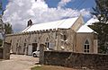
St. Philip the Lesser church in the parish

See also
 In Spanish: Parroquia de Saint Philip (Barbados) para niños
