
Sainte-Anne River (La Haute-Gaspésie) facts for kids
Quick facts for kids Sainte-Anne River |
|
|---|---|

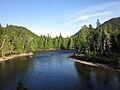
Rivière Sainte-Anne dans le parc national de la Gaspésie
|
|

|
|
| Native name | Rivière Sainte-Anne |
| Other name(s) | Old name: Rivière Sainte-Anne-des-Months |
| Country | Canada |
| Province | Quebec |
| Region | Gaspésie-Îles-de-la-Madeleine |
| MRC | La Haute-Gaspésie Regional County Municipality |
| Physical characteristics | |
| Main source | Lake Sainte-Anne Mont-Albert 414 metres (1,358 ft) 48°48′34″N 66°04′24″E / 48.809323°N 66.07341°E |
| River mouth | St. Lawrence River Sainte-Anne-des-Monts 2 metres (6 ft 7 in) 49°07′33″N 66°30′19″E / 49.12583°N 66.50528°E |
| Length | 740 kilometres (460 mi) |
| Basin features | |
| Tributaries |
|
The Sainte-Anne River (called rivière Sainte-Anne in French) is a river in Quebec, Canada. It flows into the St. Lawrence River on its south side. This river is found in the Gaspésie-Îles-de-la-Madeleine region, within the La Haute-Gaspésie Regional County Municipality.
Contents
What Lives in the Sainte-Anne River?
The Sainte-Anne River is home to four different types of fish.
- Atlantic salmon
- Brook trout
- Rainbow trout
- American eel
Where Does the Sainte-Anne River Start and End?
The River's Source: Lake Sainte-Anne
The Sainte-Anne River begins at Lake Sainte-Anne. This lake is about 5.8 kilometres (3.6 mi) long and sits 385 metres (1,263 ft) above sea level. It is located in the Notre Dame Mountains. The lake is fed by Lake Mimault and the Bois stream.
Tall mountains surround Lake Sainte-Anne. Mount Lyall is 919 metres (3,015 ft) high and stands about 2.7 kilometres (1.7 mi) to the west. Pic Sterling of Mont Vallières de Saint-Réal is 907 metres (2,976 ft) high and is about 2.5 kilometres (1.6 mi) to the northeast. The Chic-Chocs Wildlife Reserve is also found nearby, to the east of the lake.
The River's Journey North
From Lake Sainte-Anne, the river flows north for about 74.0 kilometres (46.0 mi). It travels through Gaspésie National Park. As it moves north, the river passes through several areas called townships. These include Lemieux, Lesseps, La Potardière, Courcelette, and Cap-Chat.
Near its end, the river flows through the town of Sainte-Anne-des-Monts.
Where the River Meets the Sea
The Sainte-Anne River finally flows into the Gulf of St. Lawrence. This happens right in the middle of the village of Sainte-Anne-des-Monts. The river's mouth is in a small bay called Sainte-Anne-des-Monts cove.
What Does the Name "Sainte-Anne River" Mean?
The name "rivière Sainte-Anne" became official on December 5, 1968. This was decided by the Commission de toponymie du Québec, which is the group in Quebec that names places.
Images for kids
-
The Sainte-Anne River in Gaspésie National Park.
