Salina Cruz facts for kids
Quick facts for kids
Salina Cruz
|
||
|---|---|---|
|
Municipality and town
|
||

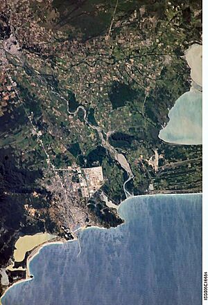
Aerial view of Salina Cruz, Oaxaca, Mexico.
|
||
|
||

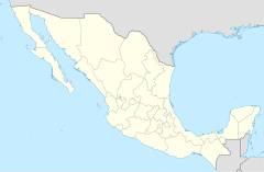
Location of the municipality in Oaxaca
|
||
| Country | Mexico | |
| State | Oaxaca | |
| Area | ||
| • Total | 131.9 km2 (50.9 sq mi) | |
| • Town | 31.7 km2 (12.2 sq mi) | |
| Population
(2020 census)
|
||
| • Total | 84,438 | |
| • Density | 640.17/km2 (1,658.0/sq mi) | |
| • Town | 76,660 | |
| • Town density | 2,418/km2 (6,263/sq mi) | |
| Time zone | UTC-6 (Central Standard Time) | |
| • Summer (DST) | UTC-5 (Central Daylight Time) | |
Salina Cruz is an important seaport city on Mexico's Pacific coast. It is located in the state of Oaxaca. It is the fourth-largest city in Oaxaca. It is also the main town of its municipality, which has the same name.
The city is part of the Isthmus of Tehuantepec region. In 2020, about 76,660 people lived in the city. The whole area, called the municipality, had 84,438 people. It covers about 131.9 square kilometers.
This port became important in the late 1800s. It was the southern end of the Tren Interoceánico (Interoceanic Train). This train helped move goods across the narrow Isthmus of Tehuantepec.
Contents
History of Salina Cruz
Salina Cruz was started in 1522 by the Spanish. Pedro de Alvarado was in charge. They named it "Salina de la Santa Cruz." This was because its official founding day was a Catholic holy day.
Salina Cruz is near where the Río Tehuantepec meets the ocean. It is on the Gulf of Tehuantepec. The area did not have a natural harbor. There was only a small village of native people before.
The Mexican government chose Salina Cruz to be the Pacific end of the Tehuantepec National Railway. They built a modern town nearby. They also built an artificial harbor. This was to handle all the ships and goods expected.
Building the Port
The new port opened in 1907. By 1909, many workers lived there. The harbor was made by building two long walls called breakwaters. These walls curved towards each other. They left an entrance 635 feet wide.
Inside, the harbor had two parts. There were also many docks and warehouses. These warehouses had electric cranes. There were also many railway tracks. The port also had one of the largest dry docks in the world at the time. A dry dock is a place where ships can be repaired out of the water. This one was 610 feet long.
The port was designed to move a huge amount of goods across the country. Even before it was finished, four shipping companies planned to use Salina Cruz regularly.
The Municipality of Salina Cruz
The city of Salina Cruz is the main town for its municipality. A municipality is like a county or district. It includes the city and several smaller communities.
Some of these communities are:
- Agua Blanca
- Boca del Río
- Colonia el Bosque
- Colonia el Mirador
- Colonia Estibadores
- Colonia Granadillo
- Colonia la Brecha
- Colonia Miramar
- Colonia Santita
- Colonia Vista Hermosa
- El Ciruelo
- El Puentecito
- Ensenada de la Ventosa
- La Brecha (Rancho Moisés Aquino)
- La Hacienda (Palo Grande)
- Las Escolleras
- Palo Grande
- Playa Azul
- Playa Brasil (Brasilito)
- Salinas del Marqués
- San Antonio Monterrey
- San José del Palmar
Geography and Climate
Salina Cruz has a tropical savanna climate. This means it has a wet season and a dry season. The dry season is from November to March. Most of the rain falls in the summer. This is similar to monsoon climates in Asia.
The seasons are not very clear. They are mostly defined by when it rains. On average, Salina Cruz gets about 1122.3 millimeters of rain each year. Most of this rain falls in August, with about 330.7 millimeters. February gets very little rain, only about 1.6 millimeters.
Temperatures can often go above 35 °C (95 °F). This happens even though it is on the coast. Winters are very mild. The lowest average temperatures are above 21 °C (70 °F). Temperatures have never been recorded below 10 °C (50 °F). High temperatures are common for most of the year.
The city gets a lot of sunshine. It usually has more than 200 hours of sunshine each month. The yearly average is 2670.6 hours. This makes it a pleasant place for beaches.
| Climate data for Salina Cruz (1981–2000) | |||||||||||||
|---|---|---|---|---|---|---|---|---|---|---|---|---|---|
| Month | Jan | Feb | Mar | Apr | May | Jun | Jul | Aug | Sep | Oct | Nov | Dec | Year |
| Record high °C (°F) | 38.8 (101.8) |
38.8 (101.8) |
39.4 (102.9) |
40.3 (104.5) |
41.3 (106.3) |
40.0 (104.0) |
38.1 (100.6) |
38.0 (100.4) |
37.9 (100.2) |
37.0 (98.6) |
36.2 (97.2) |
36.2 (97.2) |
41.3 (106.3) |
| Mean daily maximum °C (°F) | 31.1 (88.0) |
31.8 (89.2) |
32.6 (90.7) |
34.1 (93.4) |
35.2 (95.4) |
34.0 (93.2) |
34.5 (94.1) |
34.2 (93.6) |
33.6 (92.5) |
33.1 (91.6) |
32.5 (90.5) |
31.5 (88.7) |
33.2 (91.8) |
| Daily mean °C (°F) | 26.3 (79.3) |
26.8 (80.2) |
27.5 (81.5) |
28.9 (84.0) |
29.9 (85.8) |
29.0 (84.2) |
29.6 (85.3) |
29.6 (85.3) |
29.0 (84.2) |
28.5 (83.3) |
28.0 (82.4) |
27.0 (80.6) |
28.3 (82.9) |
| Mean daily minimum °C (°F) | 21.5 (70.7) |
21.7 (71.1) |
22.4 (72.3) |
23.7 (74.7) |
24.6 (76.3) |
23.9 (75.0) |
24.6 (76.3) |
25.0 (77.0) |
24.4 (75.9) |
24.0 (75.2) |
23.6 (74.5) |
22.4 (72.3) |
23.5 (74.3) |
| Record low °C (°F) | 15.6 (60.1) |
16.2 (61.2) |
16.0 (60.8) |
12.6 (54.7) |
18.4 (65.1) |
17.8 (64.0) |
19.6 (67.3) |
19.8 (67.6) |
19.2 (66.6) |
17.9 (64.2) |
17.0 (62.6) |
16.6 (61.9) |
12.6 (54.7) |
| Average precipitation mm (inches) | 4.1 (0.16) |
1.6 (0.06) |
6.6 (0.26) |
3.4 (0.13) |
62.0 (2.44) |
286.0 (11.26) |
147.1 (5.79) |
330.7 (13.02) |
193.8 (7.63) |
71.6 (2.82) |
10.7 (0.42) |
4.8 (0.19) |
1,122.3 (44.19) |
| Average precipitation days (≥ 0.1 mm) | 0.4 | 0.4 | 0.7 | 0.4 | 2.9 | 9.7 | 7.9 | 8.6 | 9.3 | 3.9 | 0.9 | 0.5 | 45.6 |
| Average relative humidity (%) | 57 | 59 | 61 | 61 | 64 | 67 | 65 | 66 | 66 | 63 | 59 | 58 | 62 |
| Mean monthly sunshine hours | 248.0 | 254.3 | 282.1 | 228.0 | 217.0 | 162.0 | 195.3 | 213.9 | 156.0 | 226.3 | 249.0 | 238.7 | 2,670.6 |
| Mean daily sunshine hours | 8.0 | 9.0 | 9.1 | 7.6 | 7.0 | 5.4 | 6.3 | 6.9 | 5.2 | 7.3 | 8.3 | 7.7 | 7.3 |
| Source 1: Servicio Meteorológico Nacional | |||||||||||||
| Source 2: Deutscher Wetterdienst (sun, 1941–1970) | |||||||||||||
See also
 In Spanish: Salina Cruz para niños
 | Emma Amos |
 | Edward Mitchell Bannister |
 | Larry D. Alexander |
 | Ernie Barnes |


