Salinas, Ecuador facts for kids
Quick facts for kids
Salinas
|
|
|---|---|
|
City
|
|

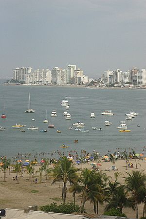
Salinas beach
|
|
| Country | |
| Province | Santa Elena |
| Canton | Salinas |
| Parishes |
List of urban parishes
Alberto Enriquez Gallo
Carlos Espinoza Larrea Santa Rosa Vicente Rocafuerte |
| Area | |
| • City | 13.38 km2 (5.17 sq mi) |
| • Metro | 73.5 km2 (28.4 sq mi) |
| Population
(2022 census)
|
|
| • City | 35,066 |
| • Density | 2,620.8/km2 (6,787.8/sq mi) |
| • Metro | 200,000 |
| (incl. La Libertad and Santa Elena) | |
| Time zone | UTC-5 (ECT) |
| Climate | BWh |
| Website | http://www.salinas.gob.ec/ |
Salinas is a lively coastal city in the Santa Elena Province of Ecuador. It's the main city of the area called Salinas Canton. This city is the most western point on mainland Ecuador.
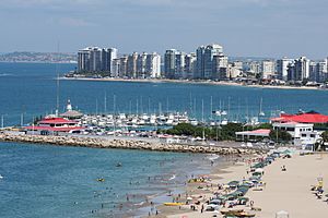
Salinas is a very popular place for tourists. It's Ecuador's biggest beach resort. Many people come here for the beautiful beaches and fun lifestyle. In 2009, Salinas hosted the ISA World Junior Surfing Games. The city has two main yacht clubs: the Salinas Yacht Club and the larger Puerto Lucia Yacht Club. Puerto Lucia has a hotel, restaurants, a private beach, and a big marina.
Salinas started as a small fishing village. It became a rural parish on June 30, 1929. Later, on December 22, 1937, it officially became a canton. The main town of the canton is Salinas itself.
Contents
Fun Things to Do in Salinas
Salinas offers many exciting activities and places to visit.
Explore the Salinas Museum
The Salinas Museum is also known as "The Museum of the Great Peninsula." You can find it on Malecon and Quil streets. It has several interesting rooms.
Ancient Cultures Room
This room shows artifacts from ancient cultures that lived on the peninsula. You can see items from the Valdivia culture (3500 - 1500 BC), Machalilla culture (1500 - 1100 BC), and the Engoroy variant of the Chorrera culture. There are also items from later periods.
You'll see human and animal figures, pots, bottles, and whistles. There are also stone axes, beads, and necklaces made from Spondylus shells.
This part of the museum has a model of a Guancavilca Manteña raft. These rafts were used by ancient people for trade. They sailed to places like Mexico and Peru.
You can also see a model of a Spanish galleon called "Jesus Maria de la Limpia Concepcion." This ship sank in 1654. The museum shows items found from the shipwreck. These include old coins, silver items, and cannonballs. There's even a gold cross and jewelry that belonged to the ship's passengers.
Surf at Punta Carnero Beach
Punta Carnero Beach is about ten minutes south of Salinas. Its name means "Ram Point." This beach is famous for surfing in Ecuador. It has hosted many national and international surf competitions.
The beach is about 1.6 miles long. It has white to gray sand and good waves. The weather is great for surfing all year round. Many people who visit Punta Carnero also travel to the Galápagos Islands. These volcanic islands are about 972 km off the coast of Ecuador.
Other Popular Attractions
Salinas has many other fun things to do:
- Go diving near the island of Peel in Ayangue.
- Try deep-sea fishing.
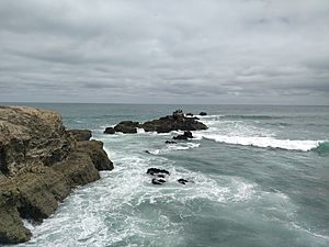
- Visit La Chocolatera, a large cliff where ocean currents meet. This makes the water look brown.
- See the Central Church of Our Lady of Mercy.
- Walk along the Main Salinas Malecon and Chipipe boardwalks.
- Relax at San Lorenzo Park Civic.
- Shop at Paseo Artesanal Los Cedros.
- Explore the Malecón de Santa Rosa.
- Visit the Park and Central Church of José Luis Tamayo.
- Shop at Pacific Mall.
- Walk along the Anconcito Malecon.
- Learn about whales at the Whale Museum.
- Go whale watching during certain times of the year.
- Try parasailing for an exciting view.
- See planes at General Ulpiano Paez Airport.
Salinas Climate
Salinas has a warm and dry climate. It's called a hot arid climate (Köppen BWh). Even though it's near the Equator, it doesn't feel hot, humid, and rainy like many tropical places. This is because of the Humboldt Current. This ocean current keeps temperatures lower for most of the year. Temperatures rise during the southern summer months.
| Climate data for Salinas (General Ulpiano Paez Airport), elevation 8 m (26 ft), (1971–2000) | |||||||||||||
|---|---|---|---|---|---|---|---|---|---|---|---|---|---|
| Month | Jan | Feb | Mar | Apr | May | Jun | Jul | Aug | Sep | Oct | Nov | Dec | Year |
| Mean daily maximum °C (°F) | 27.4 (81.3) |
28.4 (83.1) |
28.7 (83.7) |
27.7 (81.9) |
26.1 (79.0) |
24.4 (75.9) |
22.9 (73.2) |
22.8 (73.0) |
23.0 (73.4) |
23.2 (73.8) |
23.9 (75.0) |
25.5 (77.9) |
25.3 (77.6) |
| Mean daily minimum °C (°F) | 23.1 (73.6) |
23.8 (74.8) |
23.4 (74.1) |
22.5 (72.5) |
22.1 (71.8) |
20.9 (69.6) |
19.7 (67.5) |
19.4 (66.9) |
19.3 (66.7) |
19.9 (67.8) |
20.7 (69.3) |
21.6 (70.9) |
21.4 (70.5) |
| Average precipitation mm (inches) | 17.0 (0.67) |
28.0 (1.10) |
49.0 (1.93) |
14.0 (0.55) |
1.0 (0.04) |
1.0 (0.04) |
0.0 (0.0) |
0.0 (0.0) |
0.0 (0.0) |
1.0 (0.04) |
0.0 (0.0) |
0.0 (0.0) |
111 (4.37) |
| Average relative humidity (%) | 81 | 82 | 84 | 83 | 83 | 84 | 85 | 88 | 86 | 85 | 84 | 83 | 84 |
| Source: FAO | |||||||||||||
See also
 In Spanish: Salinas (Ecuador) para niños
 | Isaac Myers |
 | D. Hamilton Jackson |
 | A. Philip Randolph |


